
Yen Bai Province topographic map
Interactive map
Click on the map to display elevation.
About this map
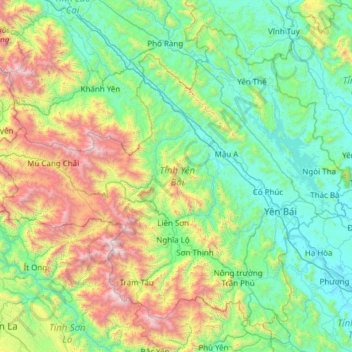
Name: Yen Bai Province topographic map, elevation, terrain.
Location: Yen Bai Province, Vietnam (21.32592 103.88624 22.29187 105.10038)
Average elevation: 644 m
Minimum elevation: 18 m
Maximum elevation: 2,941 m
The topography is steep, rising from east to west and from south to north. The average elevation is about 600 metres (2,000 ft) above sea level and can be divided into two regions: low-lying regions on the left bank of the Red River basin and the high right bank of the Red River and in the plateau between the Red River and Đà River there are many mountains. Besides the two main rivers, the Red and the Đà, the province has about 200 canals, small streams and large lakes and swamps. Thác Bà Lake is situated in the province, an artificial lake which has an area of 23,400 hectares (90 sq mi) and 1,331 islands and hills. It has a capacity of 3 to 3.9 billion cubic meters of water and its original intention was to run the Thác Bà hydroelectric plant, one of the first large hydropower projects in Vietnam. The water in the lake is blue and clear, and reflects the surrounding green forests. The thousands of hills and islands have many caves, including Hum, Cau Cuoi and Bach Xa. A Thác Bà Temple is located in the lake area. Thác Bà Lake has changed the climatic pattern in the western districts of the province, to a moderate condition from its hot and dry status.
Other topographic maps
Click on a map to view its topography, its elevation and its terrain.
Tân Lạc District
Tân Lạc District, Hoà Bình province, Vietnam
Average elevation: 416 m
Phan Thiết City
Phan Thiết City, Bình Thuận Province, Vietnam
Average elevation: 40 m
Cao Lanh City
Cao Lanh City, Đồng Tháp Province, Vietnam
Average elevation: 5 m
Quảng Yên
Quảng Yên, Quảng Ninh Province, Vietnam
Average elevation: 25 m
Vung Tau City
Vietnam > Bà Rịa - Vũng Tàu Province
Vung Tau City, Bà Rịa - Vũng Tàu Province, Vietnam
Average elevation: 3 m
Tân Yên
Vietnam > Tuyên Quang Province > Hàm Yên District
Tân Yên, Hàm Yên District, Tuyên Quang Province, Vietnam
Average elevation: 87 m
Xã Hàm Tân
Vietnam > Trà Vinh Province > Trà Cú District
Xã Hàm Tân, Trà Cú District, Trà Vinh Province, Vietnam
Average elevation: 2 m
Tuần Châu
Vietnam > Quang Ninh Province > Hạ Long City
Tuần Châu, Hạ Long City, Quảng Ninh Province, Vietnam
Average elevation: 1 m
Điện Biên Phủ
Điện Biên Phủ, Điện Biên Province, Vietnam
Average elevation: 893 m
Vị Dương
Vietnam > Quang Ninh Province > Quảng Yên
Vị Dương, Quảng Yên, Quảng Ninh Province, Vietnam
Average elevation: 2 m
Phuoc Hoa Ward
Vietnam > Bà Rịa - Vũng Tàu Province > Phú Mỹ Town
Phuoc Hoa Ward, Phú Mỹ Town, Bà Rịa - Vũng Tàu Province, Vietnam
Average elevation: 18 m
Da Lat City
Da Lat City, Lâm Đồng Province, Vietnam
Average elevation: 1,322 m
Ninh Bình
Ninh Bình, Ninh Binh province, 08000, Vietnam
Average elevation: 5 m
Tây Ninh City
Tây Ninh City, Tay Ninh province, Vietnam
Average elevation: 28 m