
Ninh Thuan province topographic map
Interactive map
Click on the map to display elevation.
About this map
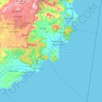
Name: Ninh Thuan province topographic map, elevation, terrain.
Location: Ninh Thuan province, Vietnam (10.76308 108.55166 12.16453 109.53737)
Average elevation: 282 m
Minimum elevation: -2 m
Maximum elevation: 2,229 m
Ninh Thuận's topography is typical for the South Central Coast in that high mountains are located not only near the western border to the Central Highlands, but also near the coast, the highest of which is Chúa mountain (Vietnamese: Núi Chúa) at 1,040 metres (3,410 ft) in the north east of the province. Several other peaks with heights up to 643 metres (2,110 ft), including Đá Bạc mountain (Vietnamese: Núi Đá Bạc) in the south, are located along the coast. The highest mountains are located at the borders to Khánh Hòa province and Lâm Đồng province, with three mountains of over 1,600 metres (5,200 ft) and the highest at 1,652 metres (5,420 ft), Sương Mù mountain (Vietnamese: Núi Sương Mù). Only a small part of the province around Phan Rang has elevations of under 50 metres (160 ft). The province's major river is the Dinh River, which flows through the main lowland of the province as well as Phan Rang. It has several tributaries in the province and is connected to Don Duong Lake in Lâm Đồng province.
Other topographic maps
Click on a map to view its topography, its elevation and its terrain.
Tân Lạc District
Tân Lạc District, Hoà Bình province, Vietnam
Average elevation: 416 m
Phan Thiết City
Phan Thiết City, Bình Thuận Province, Vietnam
Average elevation: 40 m
Cao Lanh City
Cao Lanh City, Đồng Tháp Province, Vietnam
Average elevation: 5 m
Quảng Yên
Quảng Yên, Quảng Ninh Province, Vietnam
Average elevation: 25 m
Vung Tau City
Vietnam > Bà Rịa - Vũng Tàu Province
Vung Tau City, Bà Rịa - Vũng Tàu Province, Vietnam
Average elevation: 3 m
Tân Yên
Vietnam > Tuyên Quang Province > Hàm Yên District
Tân Yên, Hàm Yên District, Tuyên Quang Province, Vietnam
Average elevation: 87 m
Xã Hàm Tân
Vietnam > Trà Vinh Province > Trà Cú District
Xã Hàm Tân, Trà Cú District, Trà Vinh Province, Vietnam
Average elevation: 2 m
Tuần Châu
Vietnam > Quang Ninh Province > Hạ Long City
Tuần Châu, Hạ Long City, Quảng Ninh Province, Vietnam
Average elevation: 1 m
Điện Biên Phủ
Điện Biên Phủ, Điện Biên Province, Vietnam
Average elevation: 893 m
Vị Dương
Vietnam > Quang Ninh Province > Quảng Yên
Vị Dương, Quảng Yên, Quảng Ninh Province, Vietnam
Average elevation: 2 m
Phuoc Hoa Ward
Vietnam > Bà Rịa - Vũng Tàu Province > Phú Mỹ Town
Phuoc Hoa Ward, Phú Mỹ Town, Bà Rịa - Vũng Tàu Province, Vietnam
Average elevation: 18 m
Da Lat City
Da Lat City, Lâm Đồng Province, Vietnam
Average elevation: 1,322 m
Ninh Bình
Ninh Bình, Ninh Binh province, 08000, Vietnam
Average elevation: 5 m
Tây Ninh City
Tây Ninh City, Tay Ninh province, Vietnam
Average elevation: 28 m