
Tân Lạc District topographic map
Interactive map
Click on the map to display elevation.
About this map
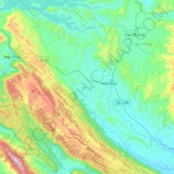
Name: Tân Lạc District topographic map, elevation, terrain.
Location: Tân Lạc District, Hoà Bình province, Vietnam (20.45130 105.11051 20.76770 105.39390)
Average elevation: 416 m
Minimum elevation: 46 m
Maximum elevation: 1,627 m
Other topographic maps
Click on a map to view its topography, its elevation and its terrain.
Hòa Bình City
Hòa Bình City, Hoà Bình province, Vietnam
Average elevation: 202 m