
Quảng Ngãi Province topographic map
Interactive map
Click on the map to display elevation.
About this map
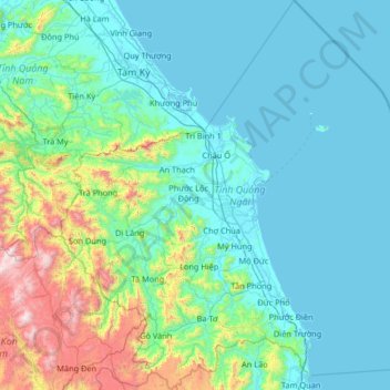
Name: Quảng Ngãi Province topographic map, elevation, terrain.
Location: Quảng Ngãi Province, Vietnam (14.53273 108.23549 15.79729 109.46323)
Average elevation: 285 m
Minimum elevation: -2 m
Maximum elevation: 2,192 m
Quảng Ngãi's topography is dominated by a large plain along the coast and in the center of the province and by mountains and hills in the west and along its borders with Quảng Nam and Bình Định provinces. Lowlands extend further inland along Trà Khúc River. The province's highest peak is at 1630m in the west of the province near the border to Quảng Nam. The coastline is relatively straight in most of the south and central part of the province (unusual for the South Central Coast), but features several capes north of Quảng Ngãi City. The province's largest river is the Trà Khúc. Other important rivers are the Trà Bồng in the north and the Ve River in the south of the province. The Lý Sơn islands belong to Quảng Ngãi.
Other topographic maps
Click on a map to view its topography, its elevation and its terrain.
Tân Lạc District
Tân Lạc District, Hoà Bình province, Vietnam
Average elevation: 416 m
Phan Thiết City
Phan Thiết City, Bình Thuận Province, Vietnam
Average elevation: 40 m
Cao Lanh City
Cao Lanh City, Đồng Tháp Province, Vietnam
Average elevation: 5 m
Quảng Yên
Quảng Yên, Quảng Ninh Province, Vietnam
Average elevation: 25 m
Vung Tau City
Vietnam > Bà Rịa - Vũng Tàu Province
Vung Tau City, Bà Rịa - Vũng Tàu Province, Vietnam
Average elevation: 3 m
Tân Yên
Vietnam > Tuyên Quang Province > Hàm Yên District
Tân Yên, Hàm Yên District, Tuyên Quang Province, Vietnam
Average elevation: 87 m
Xã Hàm Tân
Vietnam > Trà Vinh Province > Trà Cú District
Xã Hàm Tân, Trà Cú District, Trà Vinh Province, Vietnam
Average elevation: 2 m
Tuần Châu
Vietnam > Quang Ninh Province > Hạ Long City
Tuần Châu, Hạ Long City, Quảng Ninh Province, Vietnam
Average elevation: 1 m
Điện Biên Phủ
Điện Biên Phủ, Điện Biên Province, Vietnam
Average elevation: 893 m
Vị Dương
Vietnam > Quang Ninh Province > Quảng Yên
Vị Dương, Quảng Yên, Quảng Ninh Province, Vietnam
Average elevation: 2 m
Phuoc Hoa Ward
Vietnam > Bà Rịa - Vũng Tàu Province > Phú Mỹ Town
Phuoc Hoa Ward, Phú Mỹ Town, Bà Rịa - Vũng Tàu Province, Vietnam
Average elevation: 18 m
Da Lat City
Da Lat City, Lâm Đồng Province, Vietnam
Average elevation: 1,322 m
Ninh Bình
Ninh Bình, Ninh Binh province, 08000, Vietnam
Average elevation: 5 m
Tây Ninh City
Tây Ninh City, Tay Ninh province, Vietnam
Average elevation: 28 m