
Thai Nguyen province topographic map
Interactive map
Click on the map to display elevation.
About this map
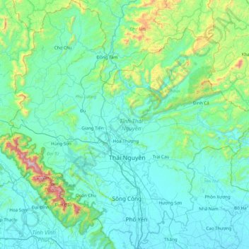
Name: Thai Nguyen province topographic map, elevation, terrain.
Location: Thai Nguyen province, Vietnam (21.32648 105.47751 22.04787 106.23798)
Average elevation: 190 m
Minimum elevation: 3 m
Maximum elevation: 1,552 m
The Tam Đảo mountain region is protected by the Tam Đảo National Park, established in 1996, which is one of the largest national parks in the country. There are over 20 peaks with the park area, others of note include Thien Thi at 1,375 m, Thach Ban at 1,388 m and Phu Nghia at 1,300 m. Sharp peaks with sloping sides and numerous, deep partitions are characteristic of the topology. The boundary of the national park is located at an altitude of 100 m around the Tam Đảo range. There is a larger buffer zone (which has area of approximately 535 km2) which surrounds the national park which has an altitude below 100 m. Seventy per cent of the area of the park is covered by natural and artificial forest. The natural forest is about 220 km2 and the human altered forest is about 30 km2
Other topographic maps
Click on a map to view its topography, its elevation and its terrain.
Tân Lạc District
Tân Lạc District, Hoà Bình province, Vietnam
Average elevation: 416 m
Phan Thiết City
Phan Thiết City, Bình Thuận Province, Vietnam
Average elevation: 40 m
Cao Lanh City
Cao Lanh City, Đồng Tháp Province, Vietnam
Average elevation: 5 m
Quảng Yên
Quảng Yên, Quảng Ninh Province, Vietnam
Average elevation: 25 m
Vung Tau City
Vietnam > Bà Rịa - Vũng Tàu Province
Vung Tau City, Bà Rịa - Vũng Tàu Province, Vietnam
Average elevation: 3 m
Tân Yên
Vietnam > Tuyên Quang Province > Hàm Yên District
Tân Yên, Hàm Yên District, Tuyên Quang Province, Vietnam
Average elevation: 87 m
Xã Hàm Tân
Vietnam > Trà Vinh Province > Trà Cú District
Xã Hàm Tân, Trà Cú District, Trà Vinh Province, Vietnam
Average elevation: 2 m
Tuần Châu
Vietnam > Quang Ninh Province > Hạ Long City
Tuần Châu, Hạ Long City, Quảng Ninh Province, Vietnam
Average elevation: 1 m
Điện Biên Phủ
Điện Biên Phủ, Điện Biên Province, Vietnam
Average elevation: 893 m
Vị Dương
Vietnam > Quang Ninh Province > Quảng Yên
Vị Dương, Quảng Yên, Quảng Ninh Province, Vietnam
Average elevation: 2 m
Phuoc Hoa Ward
Vietnam > Bà Rịa - Vũng Tàu Province > Phú Mỹ Town
Phuoc Hoa Ward, Phú Mỹ Town, Bà Rịa - Vũng Tàu Province, Vietnam
Average elevation: 18 m
Da Lat City
Da Lat City, Lâm Đồng Province, Vietnam
Average elevation: 1,322 m
Ninh Bình
Ninh Bình, Ninh Binh province, 08000, Vietnam
Average elevation: 5 m
Tây Ninh City
Tây Ninh City, Tay Ninh province, Vietnam
Average elevation: 28 m