
Quang Binh province topographic map
Interactive map
Click on the map to display elevation.
About this map
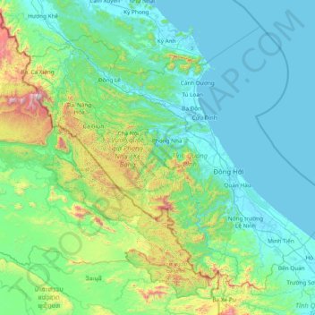
Name: Quang Binh province topographic map, elevation, terrain.
Location: Quang Binh province, Vietnam (16.92137 105.60767 18.13096 107.12337)
Average elevation: 210 m
Minimum elevation: -2 m
Maximum elevation: 1,944 m
Coordinates 16°55’ to 18°05’ North and 105°37’ to 107°00’ East. It borders Hà Tĩnh province on the north with the Ngang mountain pass as the natural frontier, Quảng Trị province to the south, Laos to the west, and faces the Dong Sea to the east. The narrowest part from east (seaside) to west (Laotian border) is just 40 km. The provincial topography is characterized by a general slope, higher in the west and lower in the east, with hilly and mountainous areas accounting for 85% of the total area. The Annamite Range is the natural border between Quảng Bình province and Laos with peaks ranging from 1,000 to 1,500 m, the summit of which is peak Phi Co Pi with the height of 2,017 m. In the east of the province are lower hills and then several narrow plains and river deltas. The seaside sand dunes belt is a natural dam that protects the land from the ocean tides.
Other topographic maps
Click on a map to view its topography, its elevation and its terrain.
Tân Lạc District
Tân Lạc District, Hoà Bình province, Vietnam
Average elevation: 416 m
Phan Thiết City
Phan Thiết City, Bình Thuận Province, Vietnam
Average elevation: 40 m
Cao Lanh City
Cao Lanh City, Đồng Tháp Province, Vietnam
Average elevation: 5 m
Quảng Yên
Quảng Yên, Quảng Ninh Province, Vietnam
Average elevation: 25 m
Vung Tau City
Vietnam > Bà Rịa - Vũng Tàu Province
Vung Tau City, Bà Rịa - Vũng Tàu Province, Vietnam
Average elevation: 3 m
Tân Yên
Vietnam > Tuyên Quang Province > Hàm Yên District
Tân Yên, Hàm Yên District, Tuyên Quang Province, Vietnam
Average elevation: 87 m
Xã Hàm Tân
Vietnam > Trà Vinh Province > Trà Cú District
Xã Hàm Tân, Trà Cú District, Trà Vinh Province, Vietnam
Average elevation: 2 m
Tuần Châu
Vietnam > Quang Ninh Province > Hạ Long City
Tuần Châu, Hạ Long City, Quảng Ninh Province, Vietnam
Average elevation: 1 m
Điện Biên Phủ
Điện Biên Phủ, Điện Biên Province, Vietnam
Average elevation: 893 m
Vị Dương
Vietnam > Quang Ninh Province > Quảng Yên
Vị Dương, Quảng Yên, Quảng Ninh Province, Vietnam
Average elevation: 2 m
Phuoc Hoa Ward
Vietnam > Bà Rịa - Vũng Tàu Province > Phú Mỹ Town
Phuoc Hoa Ward, Phú Mỹ Town, Bà Rịa - Vũng Tàu Province, Vietnam
Average elevation: 18 m
Da Lat City
Da Lat City, Lâm Đồng Province, Vietnam
Average elevation: 1,322 m
Ninh Bình
Ninh Bình, Ninh Binh province, 08000, Vietnam
Average elevation: 5 m
Tây Ninh City
Tây Ninh City, Tay Ninh province, Vietnam
Average elevation: 28 m