
Make a donation
Ninh Binh province topographic map
Click on the map to display elevation.
Make a donation
About this map
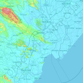
Name: Ninh Binh province topographic map, elevation, terrain.
Location: Ninh Binh province, Vietnam (19.69311 105.54170 20.45471 106.20353)
Average elevation: 25 m
Minimum elevation: -3 m
Maximum elevation: 607 m
Make a donation
Other topographic maps
Click on a map to view its topography, its elevation and its terrain.
Make a donation
Make a donation
Đà Nẵng
Geologically, Da Nang is at the edge of a Paleozoic fold belt known as the Truong Son Orogenic Zone, whose main deformation occurred during the early Carboniferous period. Da Nang's topography is dominated by the steep Annamite mountain range to the north and north-west, which features peaks ranging from 700…
Average elevation: 52 m
Make a donation
Fansipan
Vietnam > Lao Cai province > Sa Pa > Hoàng Liên
Fansipan is the tallest mountain in the Hoang Lien Son Range, situated on the border of Lào Cai Province and Lai Châu Province with its peak located on the Lào Cai side. The mountain is part of the Hoàng Liên National Park. It has a topographic prominence of 1,613 metres (5,292 ft), ranking 6th in Vietnam.
Average elevation: 2,616 m