
Tripura topographic map
Interactive map
Click on the map to display elevation.
About this map
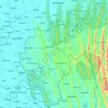
Name: Tripura topographic map, elevation, terrain.
Location: Tripura, India (22.93761 91.15081 24.53088 92.33585)
Average elevation: 85 m
Minimum elevation: 0 m
Maximum elevation: 1,320 m
The physiography is characterised by hill ranges, valleys and plains. The state has five anticlinal ranges of hills running north to south, from Boromura in the west, through Atharamura, Longtharai and Shakhan, to the Jampui Hills in the east. The intervening synclines are the Agartala–Udaipur, Khowai–Teliamura, Kamalpur–Ambasa, Kailasahar–Manu and Dharmanagar–Kanchanpur valleys. At an altitude of 939 m (3,081 ft), Betling Shib in the Jampui range is the state's highest point. The small isolated hillocks interspersed throughout the state are known as tillas, and the narrow fertile alluvial valleys, mostly present in the west, are called Doóng/lungas. A number of rivers originate in the hills of Tripura and flow into Bangladesh. The Khowai, Dhalai, Manu, Juri and Longai flow towards the north; the Gumti to the west; and the Muhuri and Feni to the south west.
Other topographic maps
Click on a map to view its topography, its elevation and its terrain.
Hyderabad
India > Telangana > Bahadurpura mandal
Hyderabad, Bahadurpura mandal, Hyderabad District, Telangana, India
Average elevation: 549 m
Thiruvananthapuram
India > Kerala > Thiruvananthapuram
Thiruvananthapuram, Thiruvananthapuram District, Kerala, 695001, India
Average elevation: 33 m
Mangaluru
India > Karnataka > Mangaluru taluk
Mangaluru, Mangaluru taluk, Dakshina Kannada District, Karnataka, 575001, India
Average elevation: 25 m
Noida
India > Uttar Pradesh > Dadri
Noida, Dadri, Gautam Buddha Nagar District, Uttar Pradesh, 201301, India
Average elevation: 216 m
Bengaluru
India > Karnataka > Bangalore North
Bengaluru, Bangalore North, Bengaluru Urban District, Karnataka, India
Average elevation: 881 m
Dehradun
India > Uttarakhand > Dehradun
Dehradun, Dehradun District, Uttarakhand, 248001, India
Average elevation: 904 m
Channasandra
India > Karnataka > Madduru taluk
Channasandra, Madduru taluk, Mandya District, Karnataka, India
Average elevation: 639 m
Mandhol
India > Himachal Pradesh > Jubbal
Mandhol, Jubbal, Shimla District, Himachal Pradesh, India
Average elevation: 2,019 m
Tarikhet
India > Uttarakhand > Ranikhet
Tarikhet, Ranikhet, Almora District, Uttarakhand, 263645, India
Average elevation: 1,525 m
Chennai
India > Tamil Nadu > Chennai
Chennai, Chennai District, Tamil Nadu, India
Average elevation: 8 m
Askot
India > Uttarakhand > Didihat
Askot, Didihat, Pithoragarh District, Uttarakhand, 262543, India
Average elevation: 1,058 m
Bhatwari
Bhatwari, Uttarkashi District, Uttarakhand, India
Average elevation: 4,570 m
Devanahalli
India > Karnataka > Devanahalli taluk
Devanahalli, Devanahalli taluk, Bengaluru Rural District, Karnataka, 562110, India
Average elevation: 900 m
Musi River
Musi River, Hyderabad, Uppal mandal, Medchal–Malkajgiri, Telangana, 5000036, India
Average elevation: 490 m
Ooty Lake
India > Tamil Nadu > Udhagamandalam > Udhagamandalam
Ooty Lake, Udhagamandalam, The Nilgiris District, Tamil Nadu, 643001, India
Average elevation: 2,235 m
Darjeeling district
Darjeeling district, West Bengal, India
Average elevation: 728 m
Dahej
India > Gujarat > Vagra Taluka
Dahej, Vagra Taluka, Bharuch District, Gujarat, 393125, India
Average elevation: 6 m
Vadodara
India > Gujarat > Vadodara Taluka
Vadodara, Vadodara Taluka, Vadodara District, Gujarat, 390001, India
Average elevation: 36 m
Thanadhar
India > Himachal Pradesh > Kumharsain
Thanadhar, Kumharsain, Shimla District, Himachal Pradesh, 172030, India
Average elevation: 1,850 m
Jubbal
Jubbal, Shimla District, Himachal Pradesh, India
Average elevation: 2,224 m
Sauni
India > Uttarakhand > Mori > Dhara
Sauni, Dhara, Mori, Uttarkashi District, Uttarakhand, India
Average elevation: 2,421 m
Begur Lake
India > Karnataka > Bangalore South
Begur Lake, Beguru, Bangalore South, Bengaluru Urban, Karnataka, India
Average elevation: 904 m
Polavaram
India > Andhra Pradesh > Kanigiri
Polavaram, Kanigiri, Prakasam, Andhra Pradesh, India
Average elevation: 93 m
Kanyakumari district
Kanyakumari district, Tamil Nadu, India
Average elevation: 226 m
Huzur Nagar Tahsil
Huzur Nagar Tahsil, Rewa District, Madhya Pradesh, India
Average elevation: 145 m
Rishikesh
India > Uttarakhand > Rishikesh
Rishikesh, Dehradun, Uttarakhand, 249201, India
Average elevation: 497 m
Bhopal
India > Madhya Pradesh > Huzur Tahsil
Bhopal, Huzur Tahsil, Bhopal District, Madhya Pradesh, 462001, India
Average elevation: 498 m
Anaikatti
India > Tamil Nadu > Coimbatore North
Anaikatti, Mannarkad, Palakkad District, Kerala, 678741, India
Average elevation: 623 m
Navi Mumbai
India > Maharashtra > Thane > Navi Mumbai
Navi Mumbai, Mumbai Metropolitan Region, Thane, Maharashtra, 400706, India
Average elevation: 30 m
Surat
India > Gujarat > Katargam Taluka > Surat
Surat, Katargam Taluka, Surat, Gujarat, 395001, India
Average elevation: 11 m