
爺ヶ岳 topographic map
Interactive map
Click on the map to display elevation.
About this map
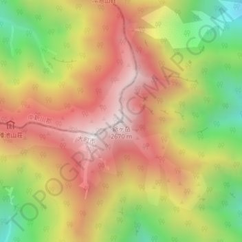
Name: 爺ヶ岳 topographic map, elevation, terrain.
Location: 爺ヶ岳, 大町市, 長野県, 日本 (36.58827 137.75088 36.58837 137.75098)
Average elevation: 2,177 m
Minimum elevation: 1,606 m
Maximum elevation: 2,649 m
爺ヶ岳(じいがたけ)は、富山県中新川郡立山町と長野県大町市にまたがる、飛騨山脈(北アルプス)・後立山連峰南部の標高2,670 mの山。山名は長野県側では「じいがたけ」と頭高型アクセントで発音される。また栂山・栂谷ノ峯・後立山・五六ヶ岳・爺岳・爺子岳の別称を持つ。
Other topographic maps
Click on a map to view its topography, its elevation and its terrain.