
鳴沢岳 topographic map
Interactive map
Click on the map to display elevation.
About this map
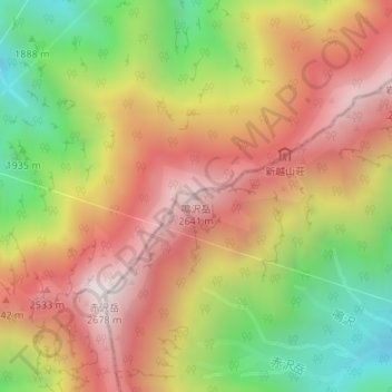
Name: 鳴沢岳 topographic map, elevation, terrain.
Location: 鳴沢岳, 大町市, 長野県, 日本 (36.56875 137.69538 36.56885 137.69548)
Average elevation: 2,138 m
Minimum elevation: 1,539 m
Maximum elevation: 2,651 m
鳴沢岳(なるさわだけ)は、飛騨山脈(北アルプス)北部の後立山連峰にある標高2,641 mの山。長野県大町市と富山県中新川郡立山町にまたがり、中部山岳国立公園内にある。
Other topographic maps
Click on a map to view its topography, its elevation and its terrain.