
槍ヶ岳 topographic map
Interactive map
Click on the map to display elevation.
About this map
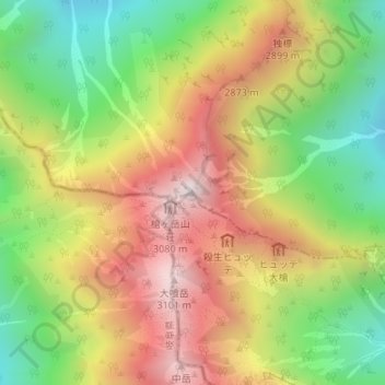
Name: 槍ヶ岳 topographic map, elevation, terrain.
Location: 槍ヶ岳, 大町市, 長野県, 日本 (36.34193 137.64758 36.34203 137.64768)
Average elevation: 2,606 m
Minimum elevation: 2,115 m
Maximum elevation: 3,129 m
槍ヶ岳(やりがたけ)は、飛騨山脈南部にある標高3,180mの山である。山域は中部山岳国立公園に指定されており、日本で5番目に高い山である。長野県松本市・大町市・岐阜県高山市の境界にある。初登攀は僧の播隆上人。日本百名山、新日本百名山及び花の百名山に選定されている。通称「槍」。
Other topographic maps
Click on a map to view its topography, its elevation and its terrain.