
前橋市 topographic map
Interactive map
Click on the map to display elevation.
About this map
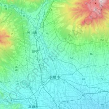
Name: 前橋市 topographic map, elevation, terrain.
Location: 前橋市, 群馬県, 日本 (36.31621 139.00162 36.56238 139.23014)
Average elevation: 340 m
Minimum elevation: 58 m
Maximum elevation: 1,804 m
また、海岸より100km以上離れた内陸に位置するにもかかわらず、市の中央部から南部にかけては海抜が100m前後と低い。また、市の北部には海抜1000m以上の地点も存在し、富士見町赤城山の黒檜山南面では海抜1823m の地点がある一方、下阿内町の利根川河川敷では海抜64m の地点もあり、市内で標高差が1759mもある。
Other topographic maps
Click on a map to view its topography, its elevation and its terrain.