
Make a donation
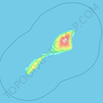
Jan Mayen topographic map
Click on the map to display elevation.
Make a donation
Jan Mayen
Jan Mayen consists of two geographically distinct parts. Nord-Jan has a round shape and is dominated by the 2,277 m (7,470 ft) high Beerenberg volcano with its large ice cap (114.2 km2 or 44 sq mi), which can be divided into twenty individual outlet glaciers. The largest of those is Sørbreen, with an area of 15 km2 (5.8 sq mi) and a length of 8.7 km (5.41 mi). South-Jan is narrow, comparatively flat and unglaciated. Its highest elevation is Rudolftoppen at 769 m (2,523 ft). The station and living quarters are located on South-Jan. The island lies at the northern end of the Jan Mayen Microcontinent. The microcontinent was originally part of the Greenland Plate, but now forms part of the Eurasian Plate.
Make a donation
About this map
Name: Jan Mayen topographic map, elevation, terrain.
Location: Jan Mayen, Norway (70.62614 -9.68463 71.35982 -7.31269)
Average elevation: 23 m
Minimum elevation: -1 m
Maximum elevation: 2,211 m
Make a donation
Other topographic maps
Click on a map to view its topography, its elevation and its terrain.
Make a donation
Snøhetta
Snøhetta is the highest mountain in the Dovrefjell mountain range in Norway. At 2,286 metres (7,500 ft), it is the highest mountain in Norway outside the Jotunheimen range, making it the 24th highest peak in Norway, based on a 30-metre (98 ft) topographic prominence cutoff. At 1,675 metres (5,495 ft), its…
Average elevation: 1,913 m
Make a donation
Make a donation
Make a donation
Make a donation
Make a donation
Make a donation