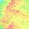
Assam topographic map
Click on the map to display elevation.
About this map
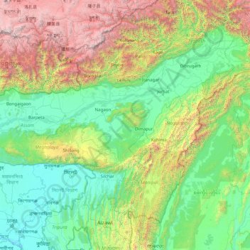
Name: Assam topographic map, elevation, terrain.
Location: Assam, India (24.13603 89.69860 27.97124 96.01244)
Average elevation: 1,142 m
Minimum elevation: -2 m
Maximum elevation: 7,324 m
Other topographic maps
Click on a map to view its topography, its elevation and its terrain.

Mangaluru
India > Karnataka > Mangaluru taluk
Mangalore is also the administrative headquarters of the Dakshina Kannada district; it is a commercial, industrial, educational, healthcare, and startup hub. The city's international airport is the second-largest and second-busiest airport in Karnataka. Mangalore City Corporation is responsible for the civic…
Average elevation: 25 m
Dehradun
India > Uttarakhand > Dehradun
The city of Dehradun mainly lies in Doon Valley and is at a varying height from 410 m (1,350 ft) in Clement Town to above 700 m (2,300 ft) at Malsi which is 15 km (9.3 mi) from the city. However, the average elevation is 450 m (1,480 ft) above sea level. Malsi is the starting point of Lesser Himalayan Range…
Average elevation: 904 m

Bhubaneshwar
India > Odisha > Bhubaneswar (M.Corp.)
Bhubaneswar is in Khordha district of Odisha. It is in the eastern coastal plains, along the axis of the Eastern Ghats mountains. The city has an average altitude of 45 m (148 ft) above sea level. It lies southwest of the Mahanadi River that forms the northern boundary of Bhubaneswar metropolitan area, within…
Average elevation: 30 m

Kakinada
India > Andhra Pradesh > Kakinada Urban Mandal
Kakinada is located at 16°56′N 82°13′E / 16.93°N 82.22°E / 16.93; 82.22. The 82-degrees east longitude passes through the city. It has an average elevation of 2 metres (6 ft), and many areas of the city are below sea level.
Average elevation: 7 m



Guntakal
India > Andhra Pradesh > Guntakal
Guntakal is located at 15°10′N 77°23′E / 15.17°N 77.38°E / 15.17; 77.38. It has an average elevation of 432 metres (1,417 ft).
Average elevation: 445 m







Ajinkyatara Fort
India > Maharashtra > Satara > Satara
Ajinkyatara Fort, also known as the "Fort of the Sapta-Rishi," is a historical hill fort located on Ajinkyatara Mountain, one of the seven mountains surrounding the city of Satara in the Sahyadri Mountains of Maharashtra, India. Situated at an altitude of 3,300 feet, the fort overlooks Satara City and is…
Average elevation: 764 m

Mysuru
India > Karnataka > Mysuru taluk
Mysore (/maɪˈsɔːr/ (listen)), officially Mysuru ([ˈmaɪˈsuːɾu] (listen)), is a city in the southern part of the state of Karnataka, India. Mysore city is geographically located between 12° 18′ 26″ north latitude and 76° 38′ 59″ east longitude. It is located at an altitude of 770 m (2,530 ft)…
Average elevation: 727 m

Sagar
India > Madhya Pradesh > Sagar Nagar Tahsil
Sagar has an average elevation of 427 metres (1401 ft) and is located in the central part of India, just north of the upper limit of the Vindhya mountain ranges.here is a lake in middle of the city.
Average elevation: 515 m
Madurai
India > Tamil Nadu > Madurai
Madurai is located at 9°56′N 78°07′E / 9.93°N 78.12°E / 9.93; 78.12. It has an average elevation of 101 metres. The city of Madurai lies on the flat and fertile plain of the river Vaigai, which runs in the northwest-southeast direction through the city, dividing it into two almost equal…
Average elevation: 138 m


Lohgad
India > Maharashtra > Mawal Subdistrict > Dudhivare
Lohagad is one of the many hill forts of Maharashtra state in India. Situated close to the hill station Lonavala and 52 km (32 mi) northwest of Pune, Lohagad rises to an elevation of 1,033 m (3,389 ft) above sea level. The fort is connected to the neighboring Visapur fort by a small range. The fort was under…
Average elevation: 797 m

Khardaha
India > West Bengal > Barrackpur - II
Khardaha is located at 22°43′N 88°23′E / 22.72°N 88.38°E / 22.72; 88.38. It has an average elevation of 15 m (49 ft). It has a railway station on the Sealdah-Ranaghat section, sandwiched between Sodepur and Sukchar (to the south) and Titagarh (to the north). The railway station divides the…
Average elevation: 7 m

Bobbili
India > Andhra Pradesh > Bobbili
Bobbili is located at 18°34′00″N 83°22′00″E / 18.5667°N 83.3667°E / 18.5667; 83.3667. It has an average elevation of 103 metres (337 feet).
Average elevation: 130 m
Mumbai
Mumbai lies at the mouth of the Ulhas River on the western coast of India, in the coastal region known as the Konkan. It sits on Salsette Island (Sashti Island), which it partially shares with the Thane district. Mumbai is bounded by the Arabian Sea to the west. Many parts of the city lie just above sea level,…
Average elevation: 13 m


Ravangla
Rabong or Ravangla is a small town with an elevation of 8000 feet located, near Namchi City in the Namchi district of the Indian state of Sikkim. It is connected by state highway to other major towns in the state and lies between Namchi, Pelling and Gangtok. It is the starting point for the trek to Maenam…
Average elevation: 1,870 m

Naharlagun
India > Arunachal Pradesh > Naharlagun EAC
It is at an altitude of 155 metres (509 ft) from sea level. Surrounded by mountains, Naharlagun is a city which sees annual long monsoon rains. The weather is sub-tropical, with hot and humid summer and temperate winter.
Average elevation: 254 m






Chintamani
India > Karnataka > Chintamani taluk
Chintamani lies in the southeast of the South Indian state of Karnataka. It is in the heart of the Mysore Plateau at an average elevation of 865 m (2,838 ft). The Taluk geographically lies between 78°12′36″N 13°16′38″E / 78.21000°N 13.27722°E / 78.21000; 13.27722 and 77°51′39″N…
Average elevation: 886 m

Western Ghats
The range starts near south of the Tapti river and runs approximately 1,600 km (990 mi) through the states of Gujarat, Maharashtra, Karnataka, Goa, Kerala and Tamil Nadu ending at Marunthuvazh Malai, Swamithope near the southern tip of India. These hills cover 160,000 km2 (62,000 sq mi) and form the catchment…
Average elevation: 2,225 m
Panaji
Panaji was annexed by India with the rest of Goa and the former Portuguese territories after the Indian annexation of Portuguese India in 1961. It became a state-capital on Goa's elevation to statehood in 1987. Between 1961 and 1987, it was the capital of the Union Territory of Goa, Daman and Diu. A new…
Average elevation: 19 m
Shimla
Shimla is on the south-western ranges of the Himalayas at 31°37′N 77°06′E / 31.61°N 77.10°E / 31.61; 77.10. It has an average altitude of 2,206 metres (7,238 ft) above mean sea level and extends along a ridge with seven spurs. The city stretches nearly 9.2 kilometres (5.7 mi) from east to west.
Average elevation: 1,557 m
Sirsi
India > Karnataka > Shirasi taluk
Sirsi is located at 14°37′N 74°51′E / 14.62°N 74.85°E / 14.62; 74.85 (Grid Square MK74).[3] It has an elevation ranging between 1860 feet to 2600 feet above sea level, and is situated in the heart of the Western Ghats. Sirsi is about 399 kilometres (248 mi) from Bangalore. The nearest airport…
Average elevation: 580 m

Lucknow
India > Uttar Pradesh > Lucknow
Lucknow stands at an elevation of approximately 123 metres (404 ft) above sea level. The city had an area of 402 km2 (155 square miles) until December 2019, when 88 villages were added to the municipal limits and the area increased to 631 km2 (244 square miles). Bounded on the east by Barabanki, on the west by…
Average elevation: 120 m
Siliguri
India > West Bengal > Matigara block
Siliguri located at the foothills of the eastern Himalayas at a location of 26°43′N 88°26′E / 26.71°N 88.43°E / 26.71; 88.43. This city is spread over an area of 260 km2 within the Siliguri Corridor, also known as the Chicken's neck. The city is surrounded by dense forests towards north and…
Average elevation: 121 m

Surat
India > Gujarat > Katargam Taluka > Surat
Surat is a port city situated on the banks of the Tapi river. Damming of the Tapi caused the original port facilities to close; the nearest port is now in the Magadalla and Hazira area of Surat Metropolitan Region.It has famous beach called 'Dumas Beach' located in Hazira. The city is located at 21°10′N…
Average elevation: 11 m