
Hung Yen Province topographic map
Interactive map
Click on the map to display elevation.
About this map
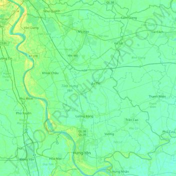
Name: Hung Yen Province topographic map, elevation, terrain.
Location: Hung Yen Province, Vietnam (20.60310 105.89532 21.00721 106.26953)
Average elevation: 5 m
Minimum elevation: -1 m
Maximum elevation: 136 m
Hưng Yên has the features of a delta province: flat topography without hills and mountains. There are 61,037 hectares of agricultural land, of which 55,645 hectares (91%) are for yearly cultivation and the remainder are for cultivation of perennial plants, fish farming, specialized cultivation and other purposes. The area of unused natural land is about 7,471 hectares, which are all available for agricultural production and development.
Other topographic maps
Click on a map to view its topography, its elevation and its terrain.
Thị trấn Hiệp Phước
Vietnam > Dong Nai province > Nhơn Trạch District
Thị trấn Hiệp Phước, Nhơn Trạch District, Đồng Nai Province, Vietnam
Average elevation: 15 m
Xã Phước Thiền
Vietnam > Dong Nai province > Nhơn Trạch District
Xã Phước Thiền, Nhơn Trạch District, Đồng Nai Province, Vietnam
Average elevation: 11 m
Tân Lạc District
Tân Lạc District, Hoà Bình province, Vietnam
Average elevation: 416 m
Phan Thiết City
Phan Thiết City, Bình Thuận Province, Vietnam
Average elevation: 40 m
Cao Lanh City
Cao Lanh City, Đồng Tháp Province, Vietnam
Average elevation: 5 m
Quảng Yên
Quảng Yên, Quảng Ninh Province, Vietnam
Average elevation: 25 m
Vung Tau City
Vietnam > Bà Rịa - Vũng Tàu Province
Vung Tau City, Bà Rịa - Vũng Tàu Province, Vietnam
Average elevation: 3 m
Tân Yên
Vietnam > Tuyên Quang Province > Hàm Yên District
Tân Yên, Hàm Yên District, Tuyên Quang Province, Vietnam
Average elevation: 87 m
Xã Hàm Tân
Vietnam > Trà Vinh Province > Trà Cú District
Xã Hàm Tân, Trà Cú District, Trà Vinh Province, Vietnam
Average elevation: 2 m
Tuần Châu
Vietnam > Quang Ninh Province > Hạ Long City
Tuần Châu, Hạ Long City, Quảng Ninh Province, Vietnam
Average elevation: 1 m
Điện Biên Phủ
Điện Biên Phủ, Điện Biên Province, Vietnam
Average elevation: 893 m
Vị Dương
Vietnam > Quang Ninh Province > Quảng Yên
Vị Dương, Quảng Yên, Quảng Ninh Province, Vietnam
Average elevation: 2 m
Phuoc Hoa Ward
Vietnam > Bà Rịa - Vũng Tàu Province > Phú Mỹ Town
Phuoc Hoa Ward, Phú Mỹ Town, Bà Rịa - Vũng Tàu Province, Vietnam
Average elevation: 18 m
Da Lat City
Da Lat City, Lâm Đồng Province, Vietnam
Average elevation: 1,322 m
Ninh Bình
Ninh Bình, Ninh Binh province, 08000, Vietnam
Average elevation: 5 m
Tây Ninh City
Tây Ninh City, Tay Ninh province, Vietnam
Average elevation: 28 m