
Gombe topographic map
Interactive map
Click on the map to display elevation.
About this map
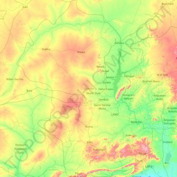
Name: Gombe topographic map, elevation, terrain.
Location: Gombe, Nigeria (9.54451 10.47313 11.31249 11.85786)
Average elevation: 388 m
Minimum elevation: 133 m
Maximum elevation: 1,023 m
Other topographic maps
Click on a map to view its topography, its elevation and its terrain.
Gangwo
Nigeria > Kebbi > Birnin Kebbi > Gangwo
Gangwo, Birnin Kebbi, Kebbi, Nigeria
Average elevation: 226 m
Gorra
Nigeria > Adamawa > Mayo-Belwa > Gorra
Gorra, Mayo-Belwa, Adamawa, Nigeria
Average elevation: 343 m
Lagos
Nigeria > Lagos > Lagos Island
Lagos, Lagos Island, Lagos, 100242, Nigeria
Average elevation: 5 m
Benin-Stadt
Nigeria > Edo > Benin-Stadt
Benin-Stadt, Oredo, Edo, 11012, Nigeria
Average elevation: 72 m
Omo Forest Reserve
Omo Forest Reserve, Ijebu East, Ogun, Nigeria
Average elevation: 83 m