
Oyo topographic map
Interactive map
Click on the map to display elevation.
About this map
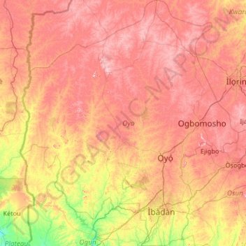
Name: Oyo topographic map, elevation, terrain.
Location: Oyo, Nigeria (7.08010 2.67693 9.18831 4.56900)
Average elevation: 271 m
Minimum elevation: 16 m
Maximum elevation: 599 m
Other topographic maps
Click on a map to view its topography, its elevation and its terrain.
Gangwo
Nigeria > Kebbi > Birnin Kebbi > Gangwo
Gangwo, Birnin Kebbi, Kebbi, Nigeria
Average elevation: 226 m
Gorra
Nigeria > Adamawa > Mayo-Belwa > Gorra
Gorra, Mayo-Belwa, Adamawa, Nigeria
Average elevation: 343 m
Lagos
Nigeria > Lagos > Lagos Island
Lagos, Lagos Island, Lagos, 100242, Nigeria
Average elevation: 5 m
Omo Forest Reserve
Omo Forest Reserve, Ijebu East, Ogun, Nigeria
Average elevation: 83 m