
Thank you for supporting this site ❤️
Make a donation
Make a donation
Kapchorwa topographic map
Click on the map to display elevation.
Thank you for supporting this site ❤️
Make a donation
Make a donation
About this map
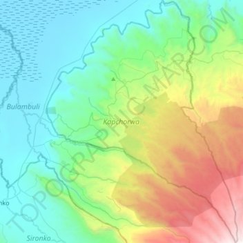
Name: Kapchorwa topographic map, elevation, terrain.
Location: Kapchorwa, Eastern Region, Uganda (1.18274 34.30503 1.47935 34.53839)
Average elevation: 1,809 m
Minimum elevation: 1,051 m
Maximum elevation: 3,987 m
Thank you for supporting this site ❤️
Make a donation
Make a donation
Other topographic maps
Click on a map to view its topography, its elevation and its terrain.
Thank you for supporting this site ❤️
Make a donation
Make a donation
Thank you for supporting this site ❤️
Make a donation
Make a donation
Thank you for supporting this site ❤️
Make a donation
Make a donation
Thank you for supporting this site ❤️
Make a donation
Make a donation
Nansana
Nansana is located on the main highway between Kampala and Hoima, the Kampala-Hoima Road. The town is located approximately 12 kilometres (7 mi), by road, north-west of Kampala, Uganda's capital and largest city. This is approximately 8 kilometres (5 mi), by road, south of Wakiso, the location of the district…
Average elevation: 1,172 m
Thank you for supporting this site ❤️
Make a donation
Make a donation
Thank you for supporting this site ❤️
Make a donation
Make a donation
Thank you for supporting this site ❤️
Make a donation
Make a donation