
Thank you for supporting this site ❤️
Make a donation
Make a donation
Cherui topographic map
Click on the map to display elevation.
Thank you for supporting this site ❤️
Make a donation
Make a donation
About this map
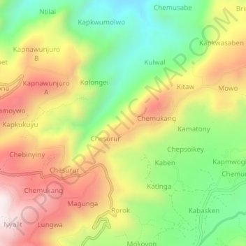
Name: Cherui topographic map, elevation, terrain.
Location: Cherui, Bukwo, Eastern Region, Uganda (1.29702 34.71367 1.33702 34.75367)
Average elevation: 1,948 m
Minimum elevation: 1,589 m
Maximum elevation: 2,347 m
Thank you for supporting this site ❤️
Make a donation
Make a donation