
Thank you for supporting this site ❤️
Make a donation
Make a donation
Dwaka topographic map
Click on the map to display elevation.
Thank you for supporting this site ❤️
Make a donation
Make a donation
About this map
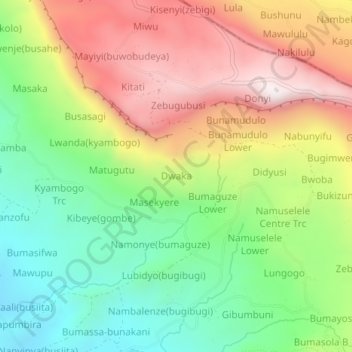
Name: Dwaka topographic map, elevation, terrain.
Location: Dwaka, Bugisa sub-region, Sironko, Eastern Region, Uganda (1.17208 34.34643 1.21208 34.38643)
Average elevation: 1,677 m
Minimum elevation: 1,255 m
Maximum elevation: 2,208 m
Thank you for supporting this site ❤️
Make a donation
Make a donation