
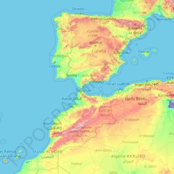
Spain topographic map
Interactive map
Click on the map to display elevation.
About this map
Name: Spain topographic map, elevation, terrain.
Location: Spain (27.43354 -18.39368 43.99331 4.59189)
Average elevation: 331 m
Minimum elevation: -31 m
Maximum elevation: 3,808 m
Mainland Spain is a rather mountainous landmass, dominated by high plateaus and mountain chains. After the Pyrenees, the main mountain ranges are the Cordillera Cantábrica (Cantabrian Range), Sistema Ibérico (Iberian System), Sistema Central (Central System), Montes de Toledo, Sierra Morena and the Sistema Bético (Baetic System) whose highest peak, the 3,478-metre-high (11,411-foot) Mulhacén, located in Sierra Nevada, is the highest elevation in the Iberian Peninsula. The highest point in Spain is the Teide, a 3,718-metre (12,198 ft) active volcano in the Canary Islands. The Meseta Central (often translated as 'Inner Plateau') is a vast plateau in the heart of peninsular Spain split in two by the Sistema Central.
Other topographic maps
Click on a map to view its topography, its elevation and its terrain.
India
India
Average elevation: 1,017 m
Madurai
India > Tamil Nadu > Madurai
Madurai, Madurai South, Madurai district, Tamil Nadu, India
Average elevation: 138 m
Sri Lanka
Sri Lanka
Average elevation: 50 m
Ooty Lake
India > Tamil Nadu > Udhagamandalam > Udhagamandalam
Ooty Lake, Udhagamandalam, The Nilgiris District, Tamil Nadu, 643001, India
Average elevation: 2,235 m
Kandy
Kandy, Kandy District, Central Province, 20000, Sri Lanka
Average elevation: 621 m
Dehradun
India > Uttarakhand > Dehradun
Dehradun, Dehradun District, Uttarakhand, 248001, India
Average elevation: 904 m
Montreal
Canada > Quebec > Urban agglomeration of Montreal > Montreal
Montreal, Urban agglomeration of Montreal, Montreal (06), Quebec, H3B 1M7, Canada
Average elevation: 30 m
Ocheretyne
Ocheretyne, Ocheretyne settlement hromada, Pokrovskii Raion, Donetsk Oblast, 86020, Ukraine
Average elevation: 227 m
Devanahalli
India > Karnataka > Devanahalli taluk
Devanahalli, Devanahalli taluk, Bengaluru Rural District, Karnataka, 562110, India
Average elevation: 900 m
Hyderabad
India > Telangana > Bahadurpura mandal
Hyderabad, Bahadurpura mandal, Hyderabad District, Telangana, India
Average elevation: 549 m
Tacoma
United States > Washington > Pierce County
Tacoma, Pierce County, Washington, United States
Average elevation: 67 m
Panvel
India > Maharashtra > Panvel > Panvel
Panvel, Raigad, Maharashtra, 410206, India
Average elevation: 75 m
West Hollywood
West Hollywood, California, United States
Average elevation: 122 m
Musi River
Musi River, Hyderabad, Uppal mandal, Medchal–Malkajgiri, Telangana, 5000036, India
Average elevation: 490 m
Hays County
United States of America > Texas
Hays County, Texas, United States of America
Average elevation: 285 m
Rampura
India > Madhya Pradesh > Gyaraspur Tahsil
Rampura, Gyaraspur Tahsil, Vidisha District, Madhya Pradesh, India
Average elevation: 460 m
Kabul
Afghanistan > Kabul Province > Kabul District
Kabul, Kabul District, Kabul Province, 1001, Afghanistan
Average elevation: 1,945 m
gehunlad
India > Uttarakhand > Chaubatta Khal
gehunlad, Chaubatta Khal, Pauri Garhwal District, Uttarakhand, India
Average elevation: 1,625 m
Snohomish County
Snohomish County, Washington, United States
Average elevation: 649 m
Mangaluru
India > Karnataka > Mangaluru taluk
Mangaluru, Mangaluru taluk, Dakshina Kannada District, Karnataka, 575001, India
Average elevation: 25 m
Thiruvananthapuram
India > Kerala > Thiruvananthapuram
Thiruvananthapuram, Thiruvananthapuram District, Kerala, 695001, India
Average elevation: 33 m
Navi Mumbai
India > Maharashtra > Thane > Navi Mumbai
Navi Mumbai, Mumbai Metropolitan Region, Thane, Maharashtra, 400706, India
Average elevation: 30 m
Delhi
India > Delhi > Kotwali Tehsil
Delhi, Kotwali Tehsil, Central Delhi, Delhi, 110006, India
Average elevation: 216 m
Pune
India > Maharashtra > Pune City > Pune
Pune, Pune City, Pune District, Maharashtra, 411001, India
Average elevation: 641 m
Bengaluru
India > Karnataka > Bangalore North
Bengaluru, Bangalore North, Bengaluru Urban District, Karnataka, India
Average elevation: 881 m
Nepal
Nepal
Average elevation: 2,604 m
Marcos Pérez
Costa Rica > Cantón Turrubares > San Luis
Marcos Pérez, San Luis, Cantón Turrubares, San Jose Province, 11604, Costa Rica
Average elevation: 216 m
Phuthaditjhaba
South Africa > Free State > Thabo Mofutsanyana District Municipality > Maluti-a-Phofung Local Municipality
Phuthaditjhaba, Maluti-a-Phofung Local Municipality, Thabo Mofutsanyana District Municipality, Free State, 9866, South Africa
Average elevation: 1,736 m
Bondapalli
India > Andhra Pradesh > Bondapalle
Bondapalli, Bondapalle, Vizianagaram, Andhra Pradesh, 531260, India
Average elevation: 72 m
Bodhupatti
India > Tamil Nadu > Namakkal
Bodhupatti, Namakkal, Namakkal District, Tamil Nadu, 637002, India
Average elevation: 193 m
Kapugollewa
Sri Lanka > North Central Province
Kapugollewa, Anuradhapura District, North Central Province, Sri Lanka
Average elevation: 65 m
Kebitigollewa
Sri Lanka > North Central Province
Kebitigollewa, Anuradhapura District, North Central Province, Sri Lanka
Average elevation: 108 m
Yacharam
India > Telangana > Bantwaram mandal
Yacharam, Bantwaram mandal, Vikarabad District, Telangana, India
Average elevation: 574 m
Mall
Pakistan > Punjab > Gujrat District
Mall, Jalalpur Jattan Tehsil, Gujrat District, Gujrat Division, Punjab, Pakistan
Average elevation: 315 m
Uhana
Uhana, Ampara District, Eastern Province, Sri Lanka
Average elevation: 42 m
Central Camp
United States > California > Madera County
Central Camp, Madera County, California, United States
Average elevation: 1,745 m
Namaloya
Namaloya, Ampara District, Eastern Province, Sri Lanka
Average elevation: 91 m