
Thank you for supporting this site ❤️
Make a donation
Make a donation
Benton County topographic map
Click on the map to display elevation.
Thank you for supporting this site ❤️
Make a donation
Make a donation
About this map
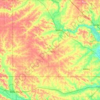
Name: Benton County topographic map, elevation, terrain.
Location: Benton County, Iowa, United States (41.86162 -92.29931 42.29905 -91.83110)
Average elevation: 268 m
Minimum elevation: 224 m
Maximum elevation: 321 m
Thank you for supporting this site ❤️
Make a donation
Make a donation
Other topographic maps
Click on a map to view its topography, its elevation and its terrain.
Iowa City
United States > Iowa > Johnson County > Iowa City
The elevation at the Iowa City Municipal Airport is 668 ft (203.6 m) above sea level.
Average elevation: 225 m
Thank you for supporting this site ❤️
Make a donation
Make a donation