
Nicaragua topographic map
Interactive map
Click on the map to display elevation.
About this map
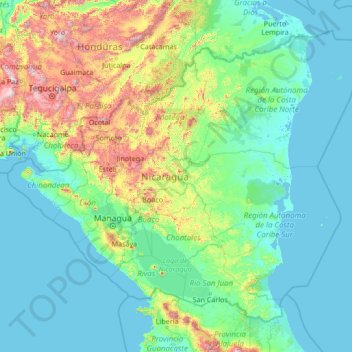
Name: Nicaragua topographic map, elevation, terrain.
Location: Nicaragua (10.70739 -87.89582 15.09028 -82.47672)
Average elevation: 238 m
Minimum elevation: -2 m
Maximum elevation: 2,292 m
Most of the Pacific zone is tierra caliente, the "hot land" of tropical Spanish America at elevations under 610 metres (2,000 ft). Temperatures remain virtually constant throughout the year, with highs ranging between 29.4 and 32.2 °C (85 and 90 °F). After a dry season lasting from November to April, rains begin in May and continue to October, giving the Pacific lowlands 1,016 to 1,524 millimetres (40 to 60 in) of precipitation. Good soils and a favourable climate combine to make western Nicaragua the country's economic and demographic centre. The southwestern shore of Lake Nicaragua lies within 24 kilometres (15 mi) of the Pacific Ocean. Thus the lake and the San Juan River were often proposed in the 19th century as the longest part of a canal route across the Central American isthmus. Canal proposals were periodically revived in the 20th and 21st centuries. Roughly a century after the opening of the Panama Canal, the prospect of a Nicaraguan ecocanal remains a topic of interest.
Other topographic maps
Click on a map to view its topography, its elevation and its terrain.
Sri Lanka
Sri Lanka
Average elevation: 50 m
Montreal
Canada > Quebec > Urban agglomeration of Montreal > Montreal
Montreal, Urban agglomeration of Montreal, Montreal (06), Quebec, H3B 1M7, Canada
Average elevation: 30 m
Madurai
India > Tamil Nadu > Madurai
Madurai, Madurai South, Madurai district, Tamil Nadu, India
Average elevation: 138 m
Hyderabad
India > Telangana > Bahadurpura mandal
Hyderabad, Bahadurpura mandal, Hyderabad District, Telangana, India
Average elevation: 549 m
Kurunegala
Sri Lanka > North Western Province
Kurunegala, Kurunegala District, North Western Province, 60000, Sri Lanka
Average elevation: 146 m
Snohomish County
Snohomish County, Washington, United States
Average elevation: 649 m
Bengaluru
India > Karnataka > Bangalore North
Bengaluru, Bangalore North, Bengaluru Urban District, Karnataka, India
Average elevation: 881 m
Kasimov
Kasimov, Ryazan Oblast, Central Federal District, Russia
Average elevation: 124 m
Labinsk
Russia > Krasnodar Krai > Labinsky District
Labinsk, Лабинское городское поселение, Labinsky District, Krasnodar Krai, Southern Federal District, Russia
Average elevation: 282 m
Hagala State
Hagala State, Kandy District, Central Province, Sri Lanka
Average elevation: 1,050 m
Panwila
Panwila, Kandy District, Central Province, 20810, Sri Lanka
Average elevation: 755 m
Malvern
United Kingdom > England > Worcestershire > Malvern Hills
Malvern, Malvern Hills, Worcestershire, England, WR14 2HX, United Kingdom
Average elevation: 95 m
Oryol
Oryol, Oryol Oblast, Central Federal District, Russia
Average elevation: 196 m
Kursk
Kursk, Kursk Oblast, Central Federal District, 305000, Russia
Average elevation: 192 m
Chennai
India > Tamil Nadu > Chennai
Chennai, Chennai District, Tamil Nadu, India
Average elevation: 8 m
India
India
Average elevation: 1,017 m
Lonavala
India > Maharashtra > Mawal
Lonavala, Mawal, Pune, Maharashtra, 410400, India
Average elevation: 613 m
Udaipur
India > Rajasthan > Girwa Tehsil
Udaipur, Girwa Tehsil, Udaipur District, Rajasthan, 313001, India
Average elevation: 656 m
Siliguri
India > West Bengal > Siliguri Subdivsion
Siliguri, Siliguri Subdivsion, Darjeeling District, West Bengal, India
Average elevation: 121 m
Thanjavur
India > Tamil Nadu > Thanjavur
Thanjavur, Thanjavur District, Tamil Nadu, 613001, India
Average elevation: 49 m
Pittsburgh
United States > Pennsylvania > Allegheny County
Pittsburgh, Allegheny County, Pennsylvania, United States
Average elevation: 303 m
Timashevsk
Russia > Krasnodar Krai > Timashyovsky District
Timashevsk, Тимашёвское городское поселение, Timashyovsky District, Krasnodar Krai, Southern Federal District, 352700, Russia
Average elevation: 17 m
Ocheretyne
Ocheretyne, Ocheretyne settlement hromada, Pokrovskii Raion, Donetsk Oblast, 86020, Ukraine
Average elevation: 227 m
Tacoma
United States > Washington > Pierce County
Tacoma, Pierce County, Washington, United States
Average elevation: 67 m
Hays County
United States of America > Texas
Hays County, Texas, United States of America
Average elevation: 285 m
Dehradun
India > Uttarakhand > Dehradun
Dehradun, Dehradun District, Uttarakhand, 248001, India
Average elevation: 904 m
Кущёвское сельское поселение
Russia > Krasnodar Krai > Kushchovsky District
Кущёвское сельское поселение, Kushchovsky District, Krasnodar Krai, Southern Federal District, Russia
Average elevation: 48 m
Rostov-on-Don
Russia > Rostov Oblast > Rostov-on-Don
Rostov-on-Don, Rostov Oblast, Southern Federal District, Russia
Average elevation: 51 m
Chhatri
India > Himachal Pradesh > Thunag
Chhatri, Thunag, Mandi District, Himachal Pradesh, India
Average elevation: 2,079 m
Briartown
United States > Kentucky > Washington County > Springfield
Briartown, Springfield, Washington County, Kentucky, 40069, United States
Average elevation: 233 m
Cranbrook
Canada > British Columbia > Regional District of East Kootenay
Cranbrook, Regional District of East Kootenay, British Columbia, Canada
Average elevation: 991 m
West Hollywood
West Hollywood, California, United States
Average elevation: 122 m
Musi River
Musi River, Hyderabad, Uppal mandal, Medchal–Malkajgiri, Telangana, 5000036, India
Average elevation: 490 m