
Angola topographic map
Interactive map
Click on the map to display elevation.
About this map
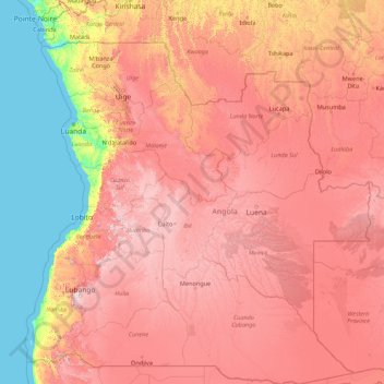
Name: Angola topographic map, elevation, terrain.
Location: Angola (-18.03938 11.46098 -4.34580 24.08764)
Average elevation: 834 m
Minimum elevation: 0 m
Maximum elevation: 2,468 m
Like the rest of tropical Africa, Angola experiences distinct, alternating rainy and dry seasons. In the north, the rainy season may last for as long as seven months—usually from September to April, with perhaps a brief slackening in January or February. In the south, the rainy season begins later, in November, and lasts until about February. The dry season (cacimbo) is often characterized by a heavy morning mist. In general, precipitation is higher in the north, but at any latitude it is greater in the interior than along the coast and increases with altitude. Temperatures fall with distance from the equator and with altitude and tend to rise closer to the Atlantic Ocean. Thus, at Soyo, at the mouth of the Congo River, the average annual temperature is about 26 °C, but it is under 16 °C at Huambo on the temperate central plateau. The coolest months are July and August (in the middle of the dry season), when frost may sometimes form at higher altitudes.
Other topographic maps
Click on a map to view its topography, its elevation and its terrain.
India
India
Average elevation: 1,017 m
Hyderabad
India > Telangana > Bahadurpura mandal
Hyderabad, Bahadurpura mandal, Hyderabad District, Telangana, India
Average elevation: 549 m
Montreal
Canada > Quebec > Urban agglomeration of Montreal > Montreal
Montreal, Urban agglomeration of Montreal, Montreal (06), Quebec, H3B 1M7, Canada
Average elevation: 30 m
Dharamshala
India > Himachal Pradesh > Dharamshala
Dharamshala, Kangra District, Himachal Pradesh, 176200, India
Average elevation: 1,781 m
Tacoma
United States > Washington > Pierce County
Tacoma, Pierce County, Washington, United States
Average elevation: 67 m
Bhopal
India > Madhya Pradesh > Huzur Tahsil
Bhopal, Huzur Tahsil, Bhopal District, Madhya Pradesh, 462001, India
Average elevation: 498 m
Bengaluru
India > Karnataka > Bangalore North
Bengaluru, Bangalore North, Bengaluru Urban District, Karnataka, India
Average elevation: 881 m
Sri Lanka
Sri Lanka
Average elevation: 50 m
Yachats
United States > Oregon > Lincoln County
Yachats, Lincoln County, Oregon, United States
Average elevation: 53 m
Nosmeh
Iran > Paveh County > دهستان شمشیر
Nosmeh, دهستان شمشیر, بخش مرکزی پاوه, Paveh County, Kermanshah Province, Iran
Average elevation: 1,778 m
Ethiopia
Ethiopia
Average elevation: 846 m
Haywood County
United States > North Carolina
Haywood County, North Carolina, United States
Average elevation: 1,044 m
Anaikatti
India > Tamil Nadu > Coimbatore North
Anaikatti, Mannarkad, Palakkad District, Kerala, 678741, India
Average elevation: 623 m
Snohomish County
Snohomish County, Washington, United States
Average elevation: 649 m
Colombo
Colombo, Colombo District, Western Province, Sri Lanka
Average elevation: 5 m
Krishnagiri District
Krishnagiri District, Tamil Nadu, India
Average elevation: 653 m
Madurai
India > Tamil Nadu > Madurai
Madurai, Madurai South, Madurai district, Tamil Nadu, India
Average elevation: 138 m
Nepal
Nepal
Average elevation: 2,604 m
Gajac
Croatia > Lika-Senj County > Grad Novalja
Gajac, Grad Novalja, Lika-Senj County, 53291, Croatia
Average elevation: 8 m
Kishangarh
India > Rajasthan > Kishangarh Tehsil
Kishangarh, Kishangarh Tehsil, Ajmer District, Rajasthan, 305802, India
Average elevation: 448 m
Chitra
Panama > Veraguas > Distrito Calobre
Chitra, Distrito Calobre, Veraguas, Panama
Average elevation: 876 m
Koloriang
India > Arunachal Pradesh > Koloriang HQ
Koloriang, Koloriang HQ, Kurung Kumey District, Arunachal Pradesh, India
Average elevation: 1,791 m
Mangerton
Australia > New South Wales > Wollongong City Council
Mangerton, Wollongong City Council, New South Wales, 2500, Australia
Average elevation: 31 m
Kharki
India > Madhya Pradesh > Pandhana Tahsil
Kharki, Pandhana Tahsil, Khandwa District, Madhya Pradesh, India
Average elevation: 317 m
Sujanpur
India > Punjab > Pathankot Tahsil
Sujanpur, Pathankot Tahsil, Pathankot District, Punjab, 145023, India
Average elevation: 334 m
Kannamedi
India > Karnataka > Pavagada taluk
Kannamedi, Pavagada taluk, Tumakuru District, Karnataka, India
Average elevation: 708 m
Mambakkam
India > Tamil Nadu > Tiruporur
Mambakkam, Tiruporur, Chengalpattu District, Tamil Nadu, 600127, India
Average elevation: 16 m
Pedda Arikatla
India > Andhra Pradesh > Konakanamitla
Pedda Arikatla, Konakanamitla, Prakasam, Andhra Pradesh, 523245, India
Average elevation: 119 m
Mandi
India > Himachal Pradesh > Mandi
Mandi, Mandi District, Himachal Pradesh, 175001, India
Average elevation: 1,273 m
Ocheretyne
Ocheretyne, Ocheretyne settlement hromada, Pokrovskii Raion, Donetsk Oblast, 86020, Ukraine
Average elevation: 227 m
Kurunegala
Sri Lanka > North Western Province
Kurunegala, Kurunegala District, North Western Province, 60000, Sri Lanka
Average elevation: 146 m
Ooty Lake
India > Tamil Nadu > Udhagamandalam > Udhagamandalam
Ooty Lake, Udhagamandalam, The Nilgiris District, Tamil Nadu, 643001, India
Average elevation: 2,235 m
Devanahalli
India > Karnataka > Devanahalli taluk
Devanahalli, Devanahalli taluk, Bengaluru Rural District, Karnataka, 562110, India
Average elevation: 900 m
Hinton
United States > Iowa > Plymouth County
Hinton, Plymouth County, Iowa, 51204, United States
Average elevation: 362 m
Chasiv Yar
Chasiv Yar, Chasiv Yar urban hromada, Bakhmut Raion, Donetsk Oblast, 84551-84556, Ukraine
Average elevation: 213 m