
赤摩木古山 topographic map
Interactive map
Click on the map to display elevation.
About this map
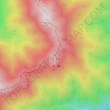
Name: 赤摩木古山 topographic map, elevation, terrain.
Location: 赤摩木古山, 金沢市, 石川県, 日本 (36.35641 136.80620 36.35651 136.80630)
Average elevation: 1,180 m
Minimum elevation: 625 m
Maximum elevation: 1,544 m
Other topographic maps
Click on a map to view its topography, its elevation and its terrain.