
Make a donation
Mt Evans topographic map
Click on the map to display elevation.
Make a donation
About this map
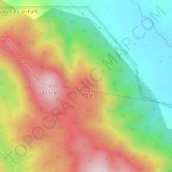
Name: Mt Evans topographic map, elevation, terrain.
Location: Mt Evans, Australian Capital Territory, Australia (-35.52050 149.03110 -35.52040 149.03120)
Average elevation: 839 m
Minimum elevation: 612 m
Maximum elevation: 1,099 m
Make a donation
Other topographic maps
Click on a map to view its topography, its elevation and its terrain.
Make a donation
Make a donation
Make a donation
Make a donation
Make a donation
Make a donation
Launceston
Launceston is at 41°26′31″S 147°8′42″E / 41.44194°S 147.14500°E / -41.44194; 147.14500 in the Tamar Valley, Northern Tasmania. The valley was formed by volcanic and glacial forces over 10 million years ago. The city is about 45 kilometres (28 mi) south of the Bass Strait, with its closest…
Average elevation: 194 m
Make a donation
Make a donation
Make a donation
Penrith
Australia > New South Wales > Sydney > Penrith
Penrith is a city in New South Wales, Australia, located in Greater Western Sydney, 55 kilometres (31 mi) west of the Sydney central business district on the banks of the Nepean River, on the outskirts of the Cumberland Plain. Its elevation is 32 metres (105 ft).
Average elevation: 34 m
Make a donation
Make a donation
Make a donation
Make a donation
Make a donation
Make a donation
Make a donation
Beaufort
Beaufort has an elevation-influenced oceanic climate (Köppen: Cfb), with tepid, relatively dry summers and cool, wetter winters. Average maxima vary from 25.3 °C (77.5 °F) in January to 10.1 °C (50.2 °F) in July, while average minima fluctuate between 11.5 °C (52.7 °F) in February and 3.2 °C (37.8 °F)…
Average elevation: 390 m
Make a donation
Make a donation
Make a donation
Make a donation
Make a donation
Make a donation
Make a donation
Make a donation
Eden Valley
Eden Valley is a small South Australian town in the Barossa Ranges. It was named by the surveyors of the area after they found the word "Eden" carved into a tree. Eden Valley has an elevation of 460 metres and an average annual rainfall of 716.2mm. Eden Valley is in the Barossa Council local government area,…
Average elevation: 369 m
Make a donation