
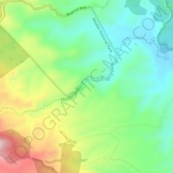
Maalan River topographic map
Interactive map
Click on the map to display elevation.
About this map
Name: Maalan River topographic map, elevation, terrain.
Average elevation: 881 m
Minimum elevation: 732 m
Maximum elevation: 1,149 m
Other topographic maps
Click on a map to view its topography, its elevation and its terrain.
Sunshine Coast
Australia > Queensland > Maroochydore
The Sunshine Coast in Queensland, Australia, showcases a diverse topography that harmoniously blends coastal plains with rugged hinterlands. Along its eastern edge, the region features expansive sandy beaches and coastal dunes that transition smoothly into fertile lowlands. Inland, the terrain becomes more…
Average elevation: 7 m
Whites Hill Reserve
Whites Hill is named after Robert (Bob) White, who, in 1873, acquired 21.5 hectares (53 acres) of land surrounding the 120 metres (390 ft) elevation now known as Whites Hill. Halfway up the hill facing Coorparoo, the White family built their family home. In 1886, White installed a powerful telescope, which he…
Average elevation: 48 m
Brisbane City
Brisbane's topography is characterized by a series of hills and ranges that define its landscape. The city is situated on a low-lying floodplain, with the Brisbane River meandering through its heart, creating a winding course with many steep curves from the southwest to its mouth at Moreton Bay in the east.…
Average elevation: 71 m
Toowoomba
The city is situated on the edge of the range and the low ridges behind it. Two valleys extend north from the southern boundary, originating from springs on either side of Middle Ridge near Spring Street, at an altitude of approximately 680 metres (2,230 ft). These waterways, East Creek and West Creek,…
Average elevation: 458 m
Cairns
Australia > Queensland > Cairns
South of Smithfield and inland from the Northern Beaches along the edge of the Barron River flood plain are the suburbs of Caravonica, Kamerunga, Freshwater, and Stratford. This area is sometimes referred to as Freshwater Valley, though it is actually the lower part of Redlynch Valley; further up the valley…
Average elevation: 176 m