
Thank you for supporting this site ❤️
Make a donation
Make a donation
Franklin topographic map
Click on the map to display elevation.
Thank you for supporting this site ❤️
Make a donation
Make a donation
About this map
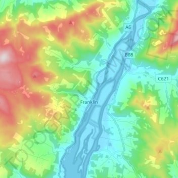
Name: Franklin topographic map, elevation, terrain.
Location: Franklin, Huon Valley, Tasmania, 7113, Australia (-43.12861 146.93369 -43.03360 147.03201)
Average elevation: 186 m
Minimum elevation: -3 m
Maximum elevation: 612 m
Thank you for supporting this site ❤️
Make a donation
Make a donation
Other topographic maps
Click on a map to view its topography, its elevation and its terrain.
Mount Wellington
"... In many parts the Eucalypti grew to a great size, and composed a noble forest. In some of the dampest ravines, tree-ferns flourished in an extraordinary manner; I saw one which must have been at least twenty feet high to the base of the fronds, and was in girth exactly six feet. The fronds forming the…
Average elevation: 941 m