
Thank you for supporting this site ❤️
Make a donation
Make a donation
Ovens topographic map
Click on the map to display elevation.
Thank you for supporting this site ❤️
Make a donation
Make a donation
About this map
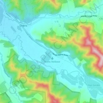
Name: Ovens topographic map, elevation, terrain.
Location: Ovens, Alpine Shire, Victoria, 3738, Australia (-36.63499 146.74844 -36.57443 146.82107)
Average elevation: 312 m
Minimum elevation: 215 m
Maximum elevation: 646 m
Thank you for supporting this site ❤️
Make a donation
Make a donation
Other topographic maps
Click on a map to view its topography, its elevation and its terrain.