
Pakistan topographic map
Interactive map
Click on the map to display elevation.
About this map
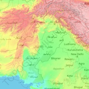
Name: Pakistan topographic map, elevation, terrain.
Location: Pakistan (23.43420 60.87286 37.08411 77.12039)
Average elevation: 1,372 m
Minimum elevation: -5 m
Maximum elevation: 7,969 m
Coniferous forests are found at altitudes ranging from 1,000 to 4,000 metres (3,300 to 13,100 feet) in most of the northern and northwestern highlands. In the xeric regions of Balochistan, date palm and Ephedra are common. In most of the Punjab and Sindh, the Indus plains support tropical and subtropical dry and moist broadleaf forest as well as tropical and xeric shrublands. About 2.2% or 1,687,000 hectares (16,870 km2) of Pakistan was forested in 2010.
Other topographic maps
Click on a map to view its topography, its elevation and its terrain.
India
India
Average elevation: 1,017 m
Sri Lanka
Sri Lanka
Average elevation: 50 m
Montreal
Canada > Quebec > Urban agglomeration of Montreal > Montreal
Montreal, Urban agglomeration of Montreal, Montreal (06), Quebec, H3B 1M7, Canada
Average elevation: 30 m
Hyderabad
India > Telangana > Bahadurpura mandal
Hyderabad, Bahadurpura mandal, Hyderabad District, Telangana, India
Average elevation: 549 m
Dehradun
India > Uttarakhand > Dehradun
Dehradun, Dehradun District, Uttarakhand, 248001, India
Average elevation: 904 m
Kandy
Kandy, Kandy District, Central Province, 20000, Sri Lanka
Average elevation: 621 m
Tacoma
United States > Washington > Pierce County
Tacoma, Pierce County, Washington, United States
Average elevation: 67 m
Siliguri
India > West Bengal > Siliguri Subdivsion
Siliguri, Siliguri Subdivsion, Darjeeling District, West Bengal, India
Average elevation: 121 m
Delhi
India > Delhi > Kotwali Tehsil
Delhi, Kotwali Tehsil, Central Delhi, Delhi, 110006, India
Average elevation: 216 m
Yachuli
India > Arunachal Pradesh > Yachuli ADC
Yachuli, Yachuli ADC, Lower Subansiri District, Arunachal Pradesh, India
Average elevation: 1,180 m
Baruipur
Baruipur, South 24 Parganas District, West Bengal, India
Average elevation: 4 m
Snohomish County
Snohomish County, Washington, United States
Average elevation: 649 m
Mangaluru
India > Karnataka > Mangaluru taluk
Mangaluru, Mangaluru taluk, Dakshina Kannada District, Karnataka, 575001, India
Average elevation: 25 m
Navi Mumbai
India > Maharashtra > Thane > Navi Mumbai
Navi Mumbai, Mumbai Metropolitan Region, Thane, Maharashtra, 400706, India
Average elevation: 30 m
Tweed
Canada > Ontario > Hastings County
Tweed, Hastings County, Central Ontario, Ontario, Canada
Average elevation: 231 m
Thiruvananthapuram
India > Kerala > Thiruvananthapuram
Thiruvananthapuram, Thiruvananthapuram District, Kerala, 695001, India
Average elevation: 33 m
Pune
India > Maharashtra > Pune City > Pune
Pune, Pune City, Pune District, Maharashtra, 411001, India
Average elevation: 641 m
Nepal
Nepal
Average elevation: 2,604 m
Devanahalli
India > Karnataka > Devanahalli taluk
Devanahalli, Devanahalli taluk, Bengaluru Rural District, Karnataka, 562110, India
Average elevation: 900 m
Calvin
United States > West Virginia > Nicholas County
Calvin, Nicholas County, West Virginia, 26660, United States
Average elevation: 708 m
Noapara
Bangladesh > Khulna Division > Abhaynagar Upazila
Noapara, Abhaynagar Upazila, Jashore District, Khulna Division, Bangladesh
Average elevation: 5 m
Deep Creek Reserve
Australia > New South Wales > Sydney
Deep Creek Reserve, North Narrabeen, Northern Beaches, Sydney, Northern Beaches Council, New South Wales, 2101, Australia
Average elevation: 50 m
Hatton
Hatton, Nuwara Eliya District, Central Province, 22050, Sri Lanka
Average elevation: 1,290 m
Grants Pass
United States > Oregon > Josephine County
Grants Pass, Josephine County, Oregon, United States
Average elevation: 377 m
Musi River
Musi River, Hyderabad, Uppal mandal, Medchal–Malkajgiri, Telangana, 5000036, India
Average elevation: 490 m
Bhuntar
Bhuntar, Kullu District, Himachal Pradesh, India
Average elevation: 3,873 m
Namau
Mozambique > Cabo Delgado Province > Metuge - Sede
Namau, Metuge - Sede, Metuge, Cabo Delgado Province, Zona Norte, Mozambique
Average elevation: 8 m
Dharamshala
India > Himachal Pradesh > Dharamshala
Dharamshala, Kangra District, Himachal Pradesh, 176200, India
Average elevation: 1,781 m
Bengaluru
India > Karnataka > Bangalore North
Bengaluru, Bangalore North, Bengaluru Urban District, Karnataka, India
Average elevation: 881 m
Thanjavur
India > Tamil Nadu > Thanjavur
Thanjavur, Thanjavur District, Tamil Nadu, 613001, India
Average elevation: 49 m
Kyslivka
Kyslivka, Петропавлівська сільська громада, Kupiansk Raion, Kharkiv Oblast, Ukraine
Average elevation: 180 m