
Guba topographic map
Interactive map
Click on the map to display elevation.
Guba
Quba (Guba) is a city and the administrative centre of the Quba District of Azerbaijan. The city lies on the north-eastern slopes of Shahdag mountain, at an altitude of 600 metres above sea level, on the right bank of the Kudyal river. It has a population of 47,200 (2023).
About this map
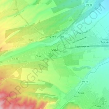
Name: Guba topographic map, elevation, terrain.
Location: Guba, Quba District, 4011, Azerbaijan (41.34062 48.45635 41.37552 48.55724)
Average elevation: 623 m
Minimum elevation: 460 m
Maximum elevation: 963 m
Other topographic maps
Click on a map to view its topography, its elevation and its terrain.
Shabran District
The greater part of the district is mountainous. The Caspian Sea is located 12 km from Shabran city. The district borders upon Quba, Khachmaz, Shamakhi and Siazan Districts. Forests occupy 27000 ha in mountainous territories and plains near the Caspian Sea and they are of great importance with their climatic…
Average elevation: 523 m
Beylagan District
Beylagan is one of the southwestern districts of Azerbaijan and situated in the Mil valley of the Kur – Araz lowland and in the middle of the Kur and Araz rivers. Geographical coordinates are 39°45’ North latitude and 47°30’ West longitude and bordering Agchabadi, Zardab, Imishli, Fuzuli districts and…
Average elevation: 58 m
Dashkasan District
The district covers the Dashkasan plateau of the Lesser Caucasian Mountain range encompassing parts and tips of Shahdagh and Murovdag ranges. The highest altitudes are at Hinaldag Peak (3,367 meters) and Qoshqar Peak (3,361 meters). Part of Bashkend-Dastafur lowlands also falls in Dashkasan rayon. This part of…
Average elevation: 1,771 m
Siazan District
The district is located in the north-eastern part of Azerbaijan, in Samur-Davachi lowland, on the shore of the Caspian Sea near the Greater Caucasus. The mountain ridge crosses the western part of the lowland extending along the Caspian Sea. Its latitude is 28 metres (92 ft). The well-known mountain of Besh…
Average elevation: 195 m
Nakhchivan Autonomous Republic
The Republic is rich in minerals. Nakhchivan possesses deposits of marble, lime, and gypsum. The deposits of the rock salt are exhausted in Nehram, Nakhchivan, and Sustin. The important molybdenum mines are currently closed as a consequence of the exclave's isolation. There are a lot of mineral springs such as…
Average elevation: 1,590 m
Ismailli District
Azerbaijan > Mountainous Shirvan
The landscape is mainly composed of mountains. Altitudes vary between 200 and 3629 meters (Babadagh) above sea level. The area is passed by the Goychay, Gyrdyman, Akhokh, Ayrichay, Sulut and other rivers, Yekekhana and Ashygbayram artificial ponds.
Average elevation: 1,009 m