
Thank you for supporting this site ❤️
Make a donation
Make a donation
Qakh District topographic map
Click on the map to display elevation.
Thank you for supporting this site ❤️
Make a donation
Make a donation
About this map
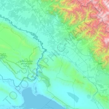
Name: Qakh District topographic map, elevation, terrain.
Location: Qakh District, Sheki-Zaqatala, Azerbaijan (40.91783 46.62392 41.59529 47.20255)
Average elevation: 591 m
Minimum elevation: 70 m
Maximum elevation: 3,778 m
Thank you for supporting this site ❤️
Make a donation
Make a donation
Other topographic maps
Click on a map to view its topography, its elevation and its terrain.