
Thank you for supporting this site ❤️
Make a donation
Make a donation
Xanlar topographic map
Click on the map to display elevation.
Thank you for supporting this site ❤️
Make a donation
Make a donation
About this map
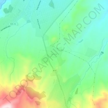
Name: Xanlar topographic map, elevation, terrain.
Location: Xanlar, Goygol District, Ganja-Dashkasan, 2500, Azerbaijan (40.54023 46.31054 40.58023 46.35054)
Average elevation: 780 m
Minimum elevation: 643 m
Maximum elevation: 1,082 m
Thank you for supporting this site ❤️
Make a donation
Make a donation
Other topographic maps
Click on a map to view its topography, its elevation and its terrain.
Dashkasan District
The district covers the Dashkasan plateau of the Lesser Caucasian Mountain range encompassing parts and tips of Shahdagh and Murovdag ranges. The highest altitudes are at Hinaldag Peak (3,367 meters) and Qoshqar Peak (3,361 meters). Part of Bashkend-Dastafur lowlands also falls in Dashkasan rayon. This part of…
Average elevation: 1,771 m
Thank you for supporting this site ❤️
Make a donation
Make a donation