
Make a donation
Quba District topographic map
Click on the map to display elevation.
Make a donation
About this map
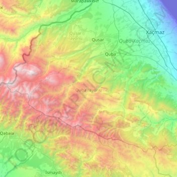
Name: Quba District topographic map, elevation, terrain.
Location: Quba District, Azerbaijan (40.88612 47.98575 41.49655 49.12104)
Average elevation: 1,286 m
Minimum elevation: -29 m
Maximum elevation: 4,424 m
Make a donation
Other topographic maps
Click on a map to view its topography, its elevation and its terrain.
Qazax
Gazakh region is located in the western part of the republic, in the western part of the vast Ganja-Gazakh plain, which starts from the slopes of the mountain range of the Lesser Caucasus and extends along the right bank of the Kura river. The highest elevation is "Odun" mountain (1316 meters). Its nature is…
Average elevation: 382 m
Make a donation
Gedabek
Gadabay lies at the northern foot of the Shahdagh Range, at an altitude of 1460 meters, on the coast of the Mis River. The city is located in the middle and high mountainous areas of the Lesser Caucasus (also called Little Caucasus).
Average elevation: 1,499 m
Make a donation
Khankendi
Stepanakert is located on the Karabakh plateau, at an average altitude of 813 m (2,667 ft) above sea level.
Average elevation: 862 m
Make a donation
Make a donation
Make a donation
Make a donation