
Travis County topographic map
Interactive map
Click on the map to display elevation.
About this map
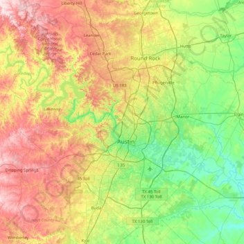
Name: Travis County topographic map, elevation, terrain.
Location: Travis County, Texas, United States (30.02333 -98.17314 30.62803 -97.36958)
Average elevation: 231 m
Minimum elevation: 102 m
Maximum elevation: 453 m
Travis County straddles the Balcones Fault, the boundary between the Edwards Plateau to the west and the Texas Coastal Plain to the east. The western part of the county is characterized by the karst topography of the Texas Hill Country, while the eastern part exhibits the fertile plains and farmlands of the Blackland Prairie. The Colorado River meanders through the county from west to east, forming a series of man-made lakes (Lake Travis, Lake Austin, and Lady Bird Lake). Lake Travis garnered national attention in September 2020 as the site of a major boating accident during a Trump Boat Parade in which five boats sank.
Other topographic maps
Click on a map to view its topography, its elevation and its terrain.
Dallas
United States > Texas > Dallas County
Dallas, Dallas County, Texas, United States
Average elevation: 160 m
League City
United States > Texas > Galveston County
League City, Galveston County, Texas, 77573, United States
Average elevation: 7 m
Bruceville
United States > Texas > McLennan County > Bruceville-Eddy
Bruceville, Bruceville-Eddy, McLennan County, Texas, 76630, United States
Average elevation: 188 m
Wylie
United States > Texas > Collin County
Wylie, Collin County, Texas, United States
Average elevation: 160 m
Missouri City
United States > Texas > Fort Bend County
Missouri City, Fort Bend County, Texas, United States
Average elevation: 22 m
Desert
United States > Texas > Collin County
Desert, Collin County, Texas, United States
Average elevation: 206 m
Rosharon
United States > Texas > Brazoria County
Rosharon, Brazoria County, Texas, United States
Average elevation: 16 m
Golinda
United States > Texas > Falls County
Golinda, Falls County, Texas, United States
Average elevation: 141 m
Nordheim
United States > Texas > DeWitt County
Nordheim, DeWitt County, Texas, United States
Average elevation: 120 m
San Angelo
United States > Texas > Tom Green County
San Angelo, Tom Green County, Texas, United States
Average elevation: 576 m
Rio Grande
United States > Texas > Starr County
Rio Grande, Starr County, Texas, United States
Average elevation: 71 m
Pine Forest
United States > Texas > Orange County
Pine Forest, Orange County, Texas, United States
Average elevation: 5 m
College Station
United States > Texas > Brazos County
College Station, Brazos County, Texas, United States
Average elevation: 87 m
Bruceville-Eddy
United States > Texas > McLennan County
Bruceville-Eddy, McLennan County, Texas, 76524, United States
Average elevation: 198 m
Mount Pleasant
United States > Texas > Titus County
Mount Pleasant, Titus County, Texas, 75455, United States
Average elevation: 115 m
Mount Pleasant
United States > Texas > Titus County
Mount Pleasant, Titus County, Texas, 75455, United States
Average elevation: 115 m
Magnolia
United States > Texas > Montgomery County
Magnolia, Montgomery County, Texas, 77353, United States
Average elevation: 77 m
Baylor County
Baylor County, Texas, 76380, United States
Average elevation: 385 m
Hudson
United States > Texas > Angelina County
Hudson, Angelina County, Texas, United States
Average elevation: 91 m
Rio Bravo
United States > Texas > Webb County
Rio Bravo, Webb County, Texas, United States
Average elevation: 130 m
Allen
United States > Texas > Collin County
Allen, Collin County, Texas, United States
Average elevation: 200 m
Levy Park
United States > Texas > Harris County > Houston
Levy Park, 3801, Greenway / Upper Kirby, Houston, Harris County, Texas, 77098, United States
Average elevation: 20 m
Boca Chica Village
United States > Texas > Cameron County
Boca Chica Village, Cameron County, Texas, United States
Average elevation: 1 m
Williamson County
Williamson County, Texas, United States
Average elevation: 222 m
Shiner
United States > Texas > Lavaca County
Shiner, Lavaca County, Texas, 77984, United States
Average elevation: 113 m
Corral City
United States > Texas > Denton County
Corral City, Denton County, Texas, United States
Average elevation: 213 m
Athens
United States > Texas > Henderson County
Athens, Henderson County, Texas, United States
Average elevation: 140 m
Amira
United States > Texas > Harris County
Amira, Harris County, Texas, United States
Average elevation: 63 m
Rock Island
United States > Texas > Colorado County
Rock Island, Colorado County, Texas, 77470, United States
Average elevation: 77 m
Grandview
United States > Texas > Johnson County
Grandview, Johnson County, Texas, United States
Average elevation: 208 m
Enchanted Rock
United States > Texas > Llano County
Enchanted Rock, Llano County, Texas, United States
Average elevation: 453 m
Elevation
United States > Texas > Milam County
Elevation, Milam County, Texas, United States
Average elevation: 150 m
Bellville
United States > Texas > Austin County > Bellville
Bellville, Austin County, Texas, United States
Average elevation: 72 m
Canyon
United States > Texas > Randall County
Canyon, Randall County, Texas, 79016, United States
Average elevation: 1,085 m
Corpus Christi
United States > Texas > Nueces County
Corpus Christi, Nueces County, Texas, United States
Average elevation: 8 m