
Poland topographic map
Interactive map
Click on the map to display elevation.
About this map
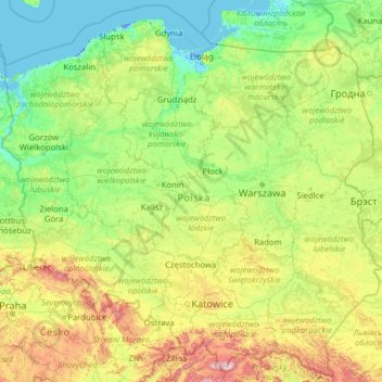
Name: Poland topographic map, elevation, terrain.
Location: Poland (49.00205 14.06964 55.03605 24.14578)
Average elevation: 194 m
Minimum elevation: -6 m
Maximum elevation: 2,237 m
The native Polish name for Poland is Polska. The name is derived from the Polans, a West Slavic tribe who inhabited the Warta River basin of present-day Greater Poland region (6th–8th century CE). The tribe's name stems from the Proto-Slavic noun pole meaning field, which in-itself originates from the Proto-Indo-European word *pleh₂- indicating flatland. The etymology alludes to the topography of the region and the flat landscape of Greater Poland. The English name Poland was formed in the 1560s, from German Pole(n) and the suffix -land, denoting a people or nation. Prior to its adoption, the Latin form Polonia was widely used throughout medieval Europe.
Other topographic maps
Click on a map to view its topography, its elevation and its terrain.
Montreal
Canada > Quebec > Urban agglomeration of Montreal > Montreal
Montreal, Urban agglomeration of Montreal, Montreal (06), Quebec, H3B 1M7, Canada
Average elevation: 30 m
India
India
Average elevation: 1,017 m
Hyderabad
India > Telangana > Bahadurpura mandal
Hyderabad, Bahadurpura mandal, Hyderabad District, Telangana, India
Average elevation: 549 m
Sri Lanka
Sri Lanka
Average elevation: 50 m
Haywood County
United States > North Carolina
Haywood County, North Carolina, United States
Average elevation: 1,044 m
Snohomish County
Snohomish County, Washington, United States
Average elevation: 649 m
Vadodara
India > Gujarat > Vadodara Taluka
Vadodara, Vadodara Taluka, Vadodara District, Gujarat, 390001, India
Average elevation: 36 m
Musi River
Musi River, Hyderabad, Uppal mandal, Medchal–Malkajgiri, Telangana, 5000036, India
Average elevation: 490 m
Osoyoos
Canada > British Columbia > Regional District of Okanagan-Similkameen
Osoyoos, Regional District of Okanagan-Similkameen, British Columbia, Canada
Average elevation: 326 m
Radda in Chianti
Radda in Chianti, Siena, Tuscany, 53017, Italy
Average elevation: 484 m
Mandhol
India > Himachal Pradesh > Jubbal
Mandhol, Jubbal, Shimla District, Himachal Pradesh, India
Average elevation: 2,019 m
Municipio Caracollo
Bolivia > Oruro > Provincia Cercado
Municipio Caracollo, Provincia Cercado, Oruro, Bolivia
Average elevation: 3,921 m
Tarikhet
India > Uttarakhand > Ranikhet
Tarikhet, Ranikhet, Almora District, Uttarakhand, 263645, India
Average elevation: 1,525 m
3d
India > Rajasthan > Ganganagar Tehsil > 1 LNP
3d, 1 LNP, Ganganagar Tehsil, Sri Ganganagar District, Rajasthan, India
Average elevation: 178 m
Tacoma
United States > Washington > Pierce County
Tacoma, Pierce County, Washington, United States
Average elevation: 67 m
Bhatwari
Bhatwari, Uttarkashi District, Uttarakhand, India
Average elevation: 4,570 m
Rupa
India > Arunachal Pradesh > Rupa SDO
Rupa, Rupa SDO, West Kameng District, Arunachal Pradesh, India
Average elevation: 1,973 m
Dharamshala
India > Himachal Pradesh > Dharamshala
Dharamshala, Kangra District, Himachal Pradesh, 176200, India
Average elevation: 1,781 m
Thiruvananthapuram
India > Kerala > Thiruvananthapuram
Thiruvananthapuram, Thiruvananthapuram District, Kerala, 695001, India
Average elevation: 33 m
Bengaluru
India > Karnataka > Bangalore North
Bengaluru, Bangalore North, Bengaluru Urban District, Karnataka, India
Average elevation: 881 m
Volos Municipality
Greece > Thessaly and Central Greece > Regional Unit of Magnesia
Volos Municipality, Regional Unit of Magnesia, Thessaly, Thessaly and Central Greece, Greece
Average elevation: 228 m
Channasandra
India > Karnataka > Madduru taluk
Channasandra, Madduru taluk, Mandya District, Karnataka, India
Average elevation: 639 m
Realp
Switzerland > Uri > Korporation Ursern
Realp, Korporation Ursern, Uri, 6491, Switzerland
Average elevation: 2,282 m
Charmouth
United Kingdom > England > Dorset
Charmouth, Dorset, England, United Kingdom
Average elevation: 50 m
Nagrota
India > Himachal Pradesh > Jawali
Nagrota, Jawali, Kangra District, Himachal Pradesh, 176027, India
Average elevation: 461 m
Monte Pellecchia
Italy > Lazio > Rieti > Scandriglia
Monte Pellecchia, Scandriglia, Rieti, Lazio, Italy
Average elevation: 1,064 m
Askot
India > Uttarakhand > Didihat
Askot, Didihat, Pithoragarh District, Uttarakhand, 262543, India
Average elevation: 1,058 m