
Make a donation
Sicily topographic map
Click on the map to display elevation.
Make a donation
Sicily
According to the Regional Agency for Waste and Water, on 10 August 1999, the weather station of Catenanuova (EN) recorded an unofficial maximum temperature of 48.5 °C (119 °F). On 11 August 2021, a new highest temperature record for Europe with a reading of 48.8 °C (119.8 °F) was set near the city of Syracuse. Total precipitation is highly variable, generally increasing with elevation. In general, the southern and southeast coast receives the least rainfall (less than 50 cm (20 in)), and the northern and northeastern highlands the most (over 100 cm (39 in)).
Make a donation
About this map
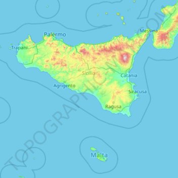
Name: Sicily topographic map, elevation, terrain.
Location: Sicily, Italy (35.49295 11.92586 38.81766 15.65308)
Average elevation: 93 m
Minimum elevation: -1 m
Maximum elevation: 3,218 m
Make a donation
Other topographic maps
Click on a map to view its topography, its elevation and its terrain.
Tre Cime di Lavaredo - Drei Zinnen
Italy > Veneto > Belluno > Auronzo di Cadore
Until 1919 the peaks formed part of the border between Italy and Austria-Hungary. Now they lie on the border between the Italian provinces of South Tyrol and Belluno and still are a part of the linguistic boundary between German-speaking and Italian-speaking majorities. The Cima Grande has an elevation of…
Average elevation: 2,242 m
Make a donation
Bologna
Italy > Emilia-Romagna > Bologna > Bologna
Bologna is situated on the edge of the Po Plain at the foot of the Apennine Mountains, at the meeting of the Reno and Savena river valleys. As Bologna's two main watercourses flow directly to the sea, the town lies outside of the drainage basin of the River Po. The Province of Bologna stretches from the…
Average elevation: 118 m
Graun im Vinschgau - Curon Venosta
Italy > Trentino – Alto Adige/Südtirol > South Tyrol > Graun - Curon Venosta
Average elevation: 1,794 m
Make a donation
Monte Cusna
Italy > Emilia-Romagna > Reggio nell'Emilia > Villa Minozzo
The mountain is located along the Appennino Crest Trail (A00) between Cerreto and Lagastrello Passes, with an altitude of 2,120 metres (6,960 ft). It is also known as Uomo Morto (Italian: "Dead Man"), "Uomo che Dorme" ("Sleeping Man") or "Il Gigante" ("The Giant") for its appearance, resembling a lying man.
Average elevation: 1,721 m
Make a donation
Rein in Taufers - Riva di Tures
Italy > Trentino – Alto Adige/Südtirol > South Tyrol
Average elevation: 1,981 m
Make a donation
Make a donation
Make a donation
Ellen - Elle
Italy > Trentino-Alto Adige/Südtirol > South Tyrol > St. Lorenzen - San Lorenzo di Sebato
Average elevation: 1,348 m
Make a donation
Make a donation
Make a donation
Make a donation
Pineta - Steinmannwald
Italy > Trentino-Alto Adige/Südtirol > South Tyrol > Laives - Leifers
Average elevation: 549 m
Make a donation
Make a donation
Naples
Italy > Campania > Napoli > Naples
The city is situated on the Gulf of Naples, on the western coast of southern Italy; it rises from sea level to an elevation of 450 metres (1,480 ft). The small rivers which formerly crossed the centre of the city have since been covered over by construction. It lies between two notable volcanic regions, Mount…
Average elevation: 58 m
Make a donation
Sant'Antonio
Italy > Calabria > Crotone > Isola di Capo Rizzuto > Sant'Antonio
Average elevation: 22 m
Make a donation
Genoa
Italy > Liguria > Genoa > Genoa
The city of Genoa covers an area of 243 square kilometres (94 sq mi) between the Ligurian Sea and the Apennine Mountains. The city stretches along the coast for about 30 kilometres (19 mi) from the neighbourhood of Voltri to Nervi, and for 10 kilometres (6.2 mi) from the coast to the north along the valleys…
Average elevation: 247 m
Make a donation
Make a donation
Pawigl - Pavicolo
Italy > Trentino-Alto Adige/Südtirol > South Tyrol > Lana
Average elevation: 1,185 m
Make a donation