
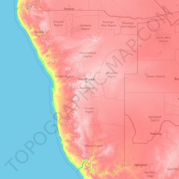
Namibia topographic map
Interactive map
Click on the map to display elevation.
About this map
Name: Namibia topographic map, elevation, terrain.
Location: Namibia (-28.96945 11.52804 -16.96351 25.26173)
Average elevation: 783 m
Minimum elevation: 0 m
Maximum elevation: 2,328 m
The Central Plateau runs from north to south, bordered by the Skeleton Coast to the northwest, the Namib Desert and its coastal plains to the southwest, the Orange River to the south, and the Kalahari Desert to the east. The Central Plateau is home to the highest point in Namibia at Königstein elevation 2,606 metres (8,550 ft).
Other topographic maps
Click on a map to view its topography, its elevation and its terrain.
India
India
Average elevation: 1,017 m
Hyderabad
India > Telangana > Bahadurpura mandal
Hyderabad, Bahadurpura mandal, Hyderabad District, Telangana, India
Average elevation: 549 m
Montreal
Canada > Quebec > Urban agglomeration of Montreal > Montreal
Montreal, Urban agglomeration of Montreal, Montreal (06), Quebec, H3B 1M7, Canada
Average elevation: 30 m
Sri Lanka
Sri Lanka
Average elevation: 50 m
Bhopal
India > Madhya Pradesh > Huzur Tahsil
Bhopal, Huzur Tahsil, Bhopal District, Madhya Pradesh, 462001, India
Average elevation: 498 m
Dharamshala
India > Himachal Pradesh > Dharamshala
Dharamshala, Kangra District, Himachal Pradesh, 176200, India
Average elevation: 1,781 m
Bengaluru
India > Karnataka > Bangalore North
Bengaluru, Bangalore North, Bengaluru Urban District, Karnataka, India
Average elevation: 881 m
Tacoma
United States > Washington > Pierce County
Tacoma, Pierce County, Washington, United States
Average elevation: 67 m
Haywood County
United States > North Carolina
Haywood County, North Carolina, United States
Average elevation: 1,044 m
Madurai
India > Tamil Nadu > Madurai
Madurai, Madurai South, Madurai district, Tamil Nadu, India
Average elevation: 138 m
Snohomish County
Snohomish County, Washington, United States
Average elevation: 649 m
Krishnagiri District
Krishnagiri District, Tamil Nadu, India
Average elevation: 653 m
Nepal
Nepal
Average elevation: 2,604 m
Anaikatti
India > Tamil Nadu > Coimbatore North
Anaikatti, Mannarkad, Palakkad District, Kerala, 678741, India
Average elevation: 623 m
Kishangarh
India > Rajasthan > Kishangarh Tehsil
Kishangarh, Kishangarh Tehsil, Ajmer District, Rajasthan, 305802, India
Average elevation: 448 m
Chitra
Panama > Veraguas > Distrito Calobre
Chitra, Distrito Calobre, Veraguas, Panama
Average elevation: 876 m
Chasiv Yar
Chasiv Yar, Chasiv Yar urban hromada, Bakhmut Raion, Donetsk Oblast, 84551-84556, Ukraine
Average elevation: 213 m
Colombo
Colombo, Colombo District, Western Province, Sri Lanka
Average elevation: 5 m
Thiruvananthapuram
India > Kerala > Thiruvananthapuram
Thiruvananthapuram, Thiruvananthapuram District, Kerala, 695001, India
Average elevation: 33 m
Koloriang
India > Arunachal Pradesh > Koloriang HQ
Koloriang, Koloriang HQ, Kurung Kumey District, Arunachal Pradesh, India
Average elevation: 1,791 m
Mangerton
Australia > New South Wales > Wollongong City Council
Mangerton, Wollongong City Council, New South Wales, 2500, Australia
Average elevation: 31 m
Kharki
India > Madhya Pradesh > Pandhana Tahsil
Kharki, Pandhana Tahsil, Khandwa District, Madhya Pradesh, India
Average elevation: 317 m
Sujanpur
India > Punjab > Pathankot Tahsil
Sujanpur, Pathankot Tahsil, Pathankot District, Punjab, 145023, India
Average elevation: 334 m
Kannamedi
India > Karnataka > Pavagada taluk
Kannamedi, Pavagada taluk, Tumakuru District, Karnataka, India
Average elevation: 708 m
Pedda Arikatla
India > Andhra Pradesh > Konakanamitla
Pedda Arikatla, Konakanamitla, Prakasam, Andhra Pradesh, 523245, India
Average elevation: 119 m
Ocheretyne
Ocheretyne, Ocheretyne settlement hromada, Pokrovskii Raion, Donetsk Oblast, 86020, Ukraine
Average elevation: 227 m
Ooty Lake
India > Tamil Nadu > Udhagamandalam > Udhagamandalam
Ooty Lake, Udhagamandalam, The Nilgiris District, Tamil Nadu, 643001, India
Average elevation: 2,235 m
Hinton
United States > Iowa > Plymouth County
Hinton, Plymouth County, Iowa, 51204, United States
Average elevation: 362 m
Kandy
Kandy, Kandy District, Central Province, 20000, Sri Lanka
Average elevation: 621 m
Mangaluru
India > Karnataka > Mangaluru taluk
Mangaluru, Mangaluru taluk, Dakshina Kannada District, Karnataka, 575001, India
Average elevation: 25 m