
Bahrain topographic map
Interactive map
Click on the map to display elevation.
About this map
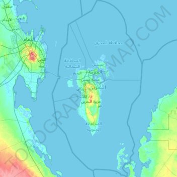
Name: Bahrain topographic map, elevation, terrain.
Location: Bahrain (25.53500 50.26980 26.68724 50.92337)
Average elevation: 6 m
Minimum elevation: -2 m
Maximum elevation: 134 m
Other topographic maps
Click on a map to view its topography, its elevation and its terrain.
India
India
Average elevation: 1,017 m
Montreal
Canada > Quebec > Urban agglomeration of Montreal > Montreal
Montreal, Urban agglomeration of Montreal, Montreal (06), Quebec, H3B 1M7, Canada
Average elevation: 30 m
Sri Lanka
Sri Lanka
Average elevation: 50 m
Hyderabad
India > Telangana > Bahadurpura mandal
Hyderabad, Bahadurpura mandal, Hyderabad District, Telangana, India
Average elevation: 549 m
Snohomish County
Snohomish County, Washington, United States
Average elevation: 649 m
Thiruvananthapuram
India > Kerala > Thiruvananthapuram
Thiruvananthapuram, Thiruvananthapuram District, Kerala, 695001, India
Average elevation: 33 m
Charmouth
United Kingdom > England > Dorset
Charmouth, Dorset, England, United Kingdom
Average elevation: 50 m
Mandhol
India > Himachal Pradesh > Jubbal
Mandhol, Jubbal, Shimla District, Himachal Pradesh, India
Average elevation: 2,019 m
Municipio Caracollo
Bolivia > Oruro > Provincia Cercado
Municipio Caracollo, Provincia Cercado, Oruro, Bolivia
Average elevation: 3,921 m
Askot
India > Uttarakhand > Didihat
Askot, Didihat, Pithoragarh District, Uttarakhand, 262543, India
Average elevation: 1,058 m
Tarikhet
India > Uttarakhand > Ranikhet
Tarikhet, Ranikhet, Almora District, Uttarakhand, 263645, India
Average elevation: 1,525 m
Tacoma
United States > Washington > Pierce County
Tacoma, Pierce County, Washington, United States
Average elevation: 67 m
Colombo District
Colombo District, Western Province, Sri Lanka
Average elevation: 22 m
Bhatwari
Bhatwari, Uttarkashi District, Uttarakhand, India
Average elevation: 4,570 m
Devanahalli
India > Karnataka > Devanahalli taluk
Devanahalli, Devanahalli taluk, Bengaluru Rural District, Karnataka, 562110, India
Average elevation: 900 m
Copalis Beach
United States > Washington > Grays Harbor County > Copalis Beach
Copalis Beach, Grays Harbor County, Washington, 98535, United States
Average elevation: 13 m
Nepal
Nepal
Average elevation: 2,604 m
Haywood County
United States > North Carolina
Haywood County, North Carolina, United States
Average elevation: 1,044 m
Musi River
Musi River, Hyderabad, Uppal mandal, Medchal–Malkajgiri, Telangana, 5000036, India
Average elevation: 490 m
Ooty Lake
India > Tamil Nadu > Udhagamandalam > Udhagamandalam
Ooty Lake, Udhagamandalam, The Nilgiris District, Tamil Nadu, 643001, India
Average elevation: 2,235 m
Monte Pellecchia
Italy > Lazio > Rieti > Scandriglia
Monte Pellecchia, Scandriglia, Rieti, Lazio, Italy
Average elevation: 1,064 m
Darjeeling district
Darjeeling district, West Bengal, India
Average elevation: 728 m
Dahej
India > Gujarat > Vagra Taluka
Dahej, Vagra Taluka, Bharuch District, Gujarat, 393125, India
Average elevation: 6 m
Kandy
Kandy, Kandy District, Central Province, 20000, Sri Lanka
Average elevation: 621 m
Vadodara
India > Gujarat > Vadodara Taluka
Vadodara, Vadodara Taluka, Vadodara District, Gujarat, 390001, India
Average elevation: 36 m
Thanadhar
India > Himachal Pradesh > Kumharsain
Thanadhar, Kumharsain, Shimla District, Himachal Pradesh, 172030, India
Average elevation: 1,850 m
Jubbal
Jubbal, Shimla District, Himachal Pradesh, India
Average elevation: 2,224 m
Sauni
India > Uttarakhand > Mori > Dhara
Sauni, Dhara, Mori, Uttarkashi District, Uttarakhand, India
Average elevation: 2,421 m