
Malaysia topographic map
Interactive map
Click on the map to display elevation.
About this map
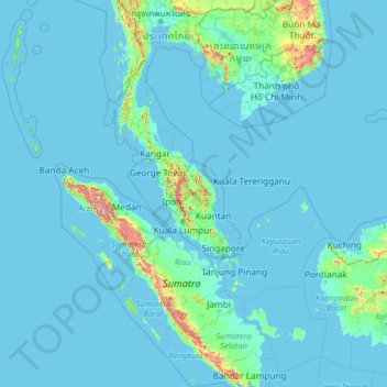
Name: Malaysia topographic map, elevation, terrain.
Location: Malaysia (0.85382 98.73651 8.38015 119.46996)
Average elevation: 54 m
Minimum elevation: -3 m
Maximum elevation: 3,191 m
The two parts of Malaysia, separated from each other by the South China Sea, share a largely similar landscape in that both Peninsular and East Malaysia feature coastal plains rising to hills and mountains. Peninsular Malaysia, containing 40 per cent of Malaysia's land area, extends 740 km (460 mi) from north to south, and its maximum width is 322 km (200 mi). It is divided between its east and west coasts by the Titiwangsa Mountains, rising to a peak elevation of 2,183 metres (7,162 ft) at Mount Korbu, part of a series of mountain ranges running down the centre of the peninsula. These mountains are heavily forested, and mainly composed of granite and other igneous rocks. Much of it has been eroded, creating a karst landscape. The range is the origin of some of Peninsular Malaysia's river systems. The coastal plains surrounding the peninsula reach a maximum width of 50 kilometres (31 mi), and the peninsula's coastline is nearly 1,931 km (1,200 mi) long, although harbours are only available on the western side.
Other topographic maps
Click on a map to view its topography, its elevation and its terrain.
India
India
Average elevation: 1,017 m
Montreal
Canada > Quebec > Urban agglomeration of Montreal > Montreal
Montreal, Urban agglomeration of Montreal, Montreal (06), Quebec, H3B 1M7, Canada
Average elevation: 30 m
Hyderabad
India > Telangana > Bahadurpura mandal
Hyderabad, Bahadurpura mandal, Hyderabad District, Telangana, India
Average elevation: 549 m
Sri Lanka
Sri Lanka
Average elevation: 50 m
Haywood County
United States > North Carolina
Haywood County, North Carolina, United States
Average elevation: 1,044 m
Vadodara
India > Gujarat > Vadodara Taluka
Vadodara, Vadodara Taluka, Vadodara District, Gujarat, 390001, India
Average elevation: 36 m
Musi River
Musi River, Hyderabad, Uppal mandal, Medchal–Malkajgiri, Telangana, 5000036, India
Average elevation: 490 m
Osoyoos
Canada > British Columbia > Regional District of Okanagan-Similkameen
Osoyoos, Regional District of Okanagan-Similkameen, British Columbia, Canada
Average elevation: 326 m
Snohomish County
Snohomish County, Washington, United States
Average elevation: 649 m
Radda in Chianti
Radda in Chianti, Siena, Tuscany, 53017, Italy
Average elevation: 484 m
Tarikhet
India > Uttarakhand > Ranikhet
Tarikhet, Ranikhet, Almora District, Uttarakhand, 263645, India
Average elevation: 1,525 m
3d
India > Rajasthan > Ganganagar Tehsil > 1 LNP
3d, 1 LNP, Ganganagar Tehsil, Sri Ganganagar District, Rajasthan, India
Average elevation: 178 m
Tacoma
United States > Washington > Pierce County
Tacoma, Pierce County, Washington, United States
Average elevation: 67 m
Rupa
India > Arunachal Pradesh > Rupa SDO
Rupa, Rupa SDO, West Kameng District, Arunachal Pradesh, India
Average elevation: 1,973 m
Dharamshala
India > Himachal Pradesh > Dharamshala
Dharamshala, Kangra District, Himachal Pradesh, 176200, India
Average elevation: 1,781 m
Thiruvananthapuram
India > Kerala > Thiruvananthapuram
Thiruvananthapuram, Thiruvananthapuram District, Kerala, 695001, India
Average elevation: 33 m
Bengaluru
India > Karnataka > Bangalore North
Bengaluru, Bangalore North, Bengaluru Urban District, Karnataka, India
Average elevation: 881 m
Volos Municipality
Greece > Thessaly and Central Greece > Regional Unit of Magnesia
Volos Municipality, Regional Unit of Magnesia, Thessaly, Thessaly and Central Greece, Greece
Average elevation: 228 m
Channasandra
India > Karnataka > Madduru taluk
Channasandra, Madduru taluk, Mandya District, Karnataka, India
Average elevation: 639 m
Realp
Switzerland > Uri > Korporation Ursern
Realp, Korporation Ursern, Uri, 6491, Switzerland
Average elevation: 2,282 m
Mandhol
India > Himachal Pradesh > Jubbal
Mandhol, Jubbal, Shimla District, Himachal Pradesh, India
Average elevation: 2,019 m
Charmouth
United Kingdom > England > Dorset
Charmouth, Dorset, England, United Kingdom
Average elevation: 50 m
Municipio Caracollo
Bolivia > Oruro > Provincia Cercado
Municipio Caracollo, Provincia Cercado, Oruro, Bolivia
Average elevation: 3,921 m
Monte Pellecchia
Italy > Lazio > Rieti > Scandriglia
Monte Pellecchia, Scandriglia, Rieti, Lazio, Italy
Average elevation: 1,064 m
Askot
India > Uttarakhand > Didihat
Askot, Didihat, Pithoragarh District, Uttarakhand, 262543, India
Average elevation: 1,058 m
Colombo District
Colombo District, Western Province, Sri Lanka
Average elevation: 22 m
Anaikatti
India > Tamil Nadu > Coimbatore North
Anaikatti, Mannarkad, Palakkad District, Kerala, 678741, India
Average elevation: 623 m