
Ladakh topographic map
Interactive map
Click on the map to display elevation.
About this map
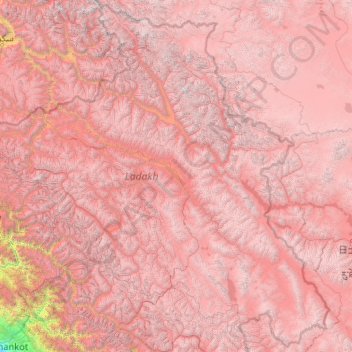
Name: Ladakh topographic map, elevation, terrain.
Location: Ladakh, India (32.33574 75.32697 35.67455 79.46075)
Average elevation: 4,726 m
Minimum elevation: 337 m
Maximum elevation: 7,470 m
The Kargil War of 1999, codenamed "Operation Vijay" by the Indian Army, saw infiltration by Pakistani troops into parts of Western Ladakh, namely Kargil, Dras, Mushkoh, Batalik and Chorbatla, overlooking key locations on the Srinagar-Leh highway. Extensive operations were launched in high altitudes by the Indian Army with considerable artillery and air force support. Pakistani troops were evicted from the Indian side of the Line of Control which the Indian government ordered was to be respected and which was not crossed by Indian troops. The Indian government was criticised by the Indian public because India respected geographical co-ordinates more than India's opponents: Pakistan and China.
Other topographic maps
Click on a map to view its topography, its elevation and its terrain.
Hyderabad
India > Telangana > Bahadurpura mandal
Hyderabad, Bahadurpura mandal, Hyderabad District, Telangana, India
Average elevation: 549 m
Tarikhet
India > Uttarakhand > Ranikhet
Tarikhet, Ranikhet, Almora District, Uttarakhand, 263645, India
Average elevation: 1,525 m
Thiruvananthapuram
India > Kerala > Thiruvananthapuram
Thiruvananthapuram, Thiruvananthapuram District, Kerala, 695001, India
Average elevation: 33 m
Channasandra
India > Karnataka > Madduru taluk
Channasandra, Madduru taluk, Mandya District, Karnataka, India
Average elevation: 639 m
Mandhol
India > Himachal Pradesh > Jubbal
Mandhol, Jubbal, Shimla District, Himachal Pradesh, India
Average elevation: 2,019 m
Askot
India > Uttarakhand > Didihat
Askot, Didihat, Pithoragarh District, Uttarakhand, 262543, India
Average elevation: 1,058 m
Bhatwari
Bhatwari, Uttarkashi District, Uttarakhand, India
Average elevation: 4,570 m
Musi River
Musi River, Hyderabad, Uppal mandal, Medchal–Malkajgiri, Telangana, 5000036, India
Average elevation: 490 m
Ooty Lake
India > Tamil Nadu > Udhagamandalam > Udhagamandalam
Ooty Lake, Udhagamandalam, The Nilgiris District, Tamil Nadu, 643001, India
Average elevation: 2,235 m
Devanahalli
India > Karnataka > Devanahalli taluk
Devanahalli, Devanahalli taluk, Bengaluru Rural District, Karnataka, 562110, India
Average elevation: 900 m
Chennai
India > Tamil Nadu > Chennai
Chennai, Chennai District, Tamil Nadu, India
Average elevation: 8 m
Mangaluru
India > Karnataka > Mangaluru taluk
Mangaluru, Mangaluru taluk, Dakshina Kannada District, Karnataka, 575001, India
Average elevation: 25 m
Noida
India > Uttar Pradesh > Dadri
Noida, Dadri, Gautam Buddha Nagar District, Uttar Pradesh, 201301, India
Average elevation: 216 m
Dehradun
India > Uttarakhand > Dehradun
Dehradun, Dehradun District, Uttarakhand, 248001, India
Average elevation: 904 m
Bhopal
India > Madhya Pradesh > Huzur Tahsil
Bhopal, Huzur Tahsil, Bhopal District, Madhya Pradesh, 462001, India
Average elevation: 498 m
Madurai
India > Tamil Nadu > Madurai
Madurai, Madurai South, Madurai district, Tamil Nadu, India
Average elevation: 138 m
Bengaluru
India > Karnataka > Bangalore North
Bengaluru, Bangalore North, Bengaluru Urban District, Karnataka, India
Average elevation: 881 m
Thanadhar
India > Himachal Pradesh > Kumharsain
Thanadhar, Kumharsain, Shimla District, Himachal Pradesh, 172030, India
Average elevation: 1,850 m
Jubbal
Jubbal, Shimla District, Himachal Pradesh, India
Average elevation: 2,224 m
Sauni
India > Uttarakhand > Mori > Dhara
Sauni, Dhara, Mori, Uttarkashi District, Uttarakhand, India
Average elevation: 2,421 m
Asarva Taluka
Asarva Taluka, Ahmedabad District, Gujarat, India
Average elevation: 57 m
Nagrota
India > Himachal Pradesh > Jawali
Nagrota, Jawali, Kangra District, Himachal Pradesh, 176027, India
Average elevation: 461 m
Naya Gurha
India > Rajasthan > Gogunda Tehsil
Naya Gurha, Gogunda Tehsil, Udaipur District, Rajasthan, 313011, India
Average elevation: 725 m
Begur Lake
India > Karnataka > Bangalore South
Begur Lake, Beguru, Bangalore South, Bengaluru Urban, Karnataka, India
Average elevation: 904 m
Polavaram
India > Andhra Pradesh > Kanigiri
Polavaram, Kanigiri, Prakasam, Andhra Pradesh, India
Average elevation: 93 m
3d
India > Rajasthan > Ganganagar Tehsil > 1 LNP
3d, 1 LNP, Ganganagar Tehsil, Sri Ganganagar District, Rajasthan, India
Average elevation: 178 m
Darjeeling district
Darjeeling district, West Bengal, India
Average elevation: 728 m
Kanyakumari district
Kanyakumari district, Tamil Nadu, India
Average elevation: 226 m
Anaikatti
India > Tamil Nadu > Coimbatore North
Anaikatti, Mannarkad, Palakkad District, Kerala, 678741, India
Average elevation: 623 m
Huzur Nagar Tahsil
Huzur Nagar Tahsil, Rewa District, Madhya Pradesh, India
Average elevation: 145 m