
Curacao topographic map
Interactive map
Click on the map to display elevation.
About this map
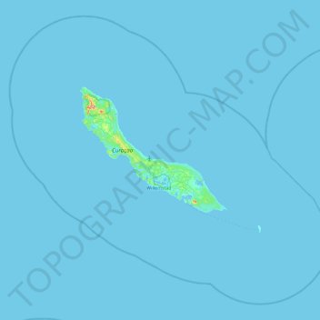
Name: Curacao topographic map, elevation, terrain.
Location: Curacao, Netherlands (11.77700 -69.36735 12.59200 -68.44133)
Average elevation: 2 m
Minimum elevation: -1 m
Maximum elevation: 288 m
Curaçao, as well as the rest of the ABC islands and Trinidad and Tobago, lies on the continental shelf of South America. It is a thin island with a generally hilly topography; the highest point is Christoffelberg in the northwest, with a peak at 372 m (1,220 ft) above sea level. The coastline's bays, inlets and hot springs offer a source of natural minerals, thermal conditions, and seawater used in hydrotherapy and mesotherapy, making the island one of many balneoclimateric areas in the region. Off the southeast coast lies the small, flat island of Klein Curaçao.
Other topographic maps
Click on a map to view its topography, its elevation and its terrain.
Montreal
Canada > Quebec > Urban agglomeration of Montreal > Montreal
Montreal, Urban agglomeration of Montreal, Montreal (06), Quebec, H3B 1M7, Canada
Average elevation: 30 m
Madurai
India > Tamil Nadu > Madurai
Madurai, Madurai South, Madurai district, Tamil Nadu, India
Average elevation: 138 m
Bengaluru
India > Karnataka > Bangalore North
Bengaluru, Bangalore North, Bengaluru Urban District, Karnataka, India
Average elevation: 881 m
Sri Lanka
Sri Lanka
Average elevation: 50 m
Malvern
United Kingdom > England > Worcestershire > Malvern Hills
Malvern, Malvern Hills, Worcestershire, England, WR14 2HX, United Kingdom
Average elevation: 95 m
India
India
Average elevation: 1,017 m
Hyderabad
India > Telangana > Bahadurpura mandal
Hyderabad, Bahadurpura mandal, Hyderabad District, Telangana, India
Average elevation: 549 m
Hays County
United States of America > Texas
Hays County, Texas, United States of America
Average elevation: 285 m
Ocheretyne
Ocheretyne, Ocheretyne settlement hromada, Pokrovskii Raion, Donetsk Oblast, 86020, Ukraine
Average elevation: 227 m
Snohomish County
Snohomish County, Washington, United States
Average elevation: 649 m
Cranbrook
Canada > British Columbia > Regional District of East Kootenay
Cranbrook, Regional District of East Kootenay, British Columbia, Canada
Average elevation: 991 m
West Hollywood
West Hollywood, California, United States
Average elevation: 122 m
Tacoma
United States > Washington > Pierce County
Tacoma, Pierce County, Washington, United States
Average elevation: 67 m
Musi River
Musi River, Hyderabad, Uppal mandal, Medchal–Malkajgiri, Telangana, 5000036, India
Average elevation: 490 m
Ooty Lake
India > Tamil Nadu > Udhagamandalam > Udhagamandalam
Ooty Lake, Udhagamandalam, The Nilgiris District, Tamil Nadu, 643001, India
Average elevation: 2,235 m
Devanahalli
India > Karnataka > Devanahalli taluk
Devanahalli, Devanahalli taluk, Bengaluru Rural District, Karnataka, 562110, India
Average elevation: 900 m
Show Low
United States > Arizona > Navajo County
Show Low, Navajo County, Arizona, 85901, United States
Average elevation: 1,957 m
Juno
South Africa > Limpopo > Capricorn District Municipality > Aganang Local Municipality
Juno, Aganang Local Municipality, Capricorn District Municipality, Limpopo, South Africa
Average elevation: 1,104 m
Chasiv Yar
Chasiv Yar, Chasiv Yar urban hromada, Bakhmut Raion, Donetsk Oblast, 84551-84556, Ukraine
Average elevation: 213 m
Kandy
Kandy, Kandy District, Central Province, 20000, Sri Lanka
Average elevation: 621 m
Navi Mumbai
India > Maharashtra > Thane > Navi Mumbai
Navi Mumbai, Mumbai Metropolitan Region, Thane, Maharashtra, 400706, India
Average elevation: 30 m
Dehradun
India > Uttarakhand > Dehradun
Dehradun, Dehradun District, Uttarakhand, 248001, India
Average elevation: 904 m
Pune
India > Maharashtra > Pune City > Pune
Pune, Pune City, Pune District, Maharashtra, 411001, India
Average elevation: 641 m
Nepal
Nepal
Average elevation: 2,604 m
Songo
Songo, Cahora-Bassa, Tete Province, Mozambique
Average elevation: 718 m
Sojha
India > Himachal Pradesh > Bali Chowki
Sojha, Bali Chowki, Mandi District, Himachal Pradesh, India
Average elevation: 2,325 m
Briartown
United States > Kentucky > Washington County > Springfield
Briartown, Springfield, Washington County, Kentucky, 40069, United States
Average elevation: 233 m
Dasada
India > Gujarat > Dasada Taluka
Dasada, Dasada Taluka, Surendranagar District, Gujarat, 382750, India
Average elevation: 28 m
Rampura
India > Madhya Pradesh > Gyaraspur Tahsil
Rampura, Gyaraspur Tahsil, Vidisha District, Madhya Pradesh, India
Average elevation: 460 m
Kabul
Afghanistan > Kabul Province > Kabul District
Kabul, Kabul District, Kabul Province, 1001, Afghanistan
Average elevation: 1,945 m
Bodhupatti
India > Tamil Nadu > Namakkal
Bodhupatti, Namakkal, Namakkal District, Tamil Nadu, 637002, India
Average elevation: 193 m
Yacharam
India > Telangana > Bantwaram mandal
Yacharam, Bantwaram mandal, Vikarabad District, Telangana, India
Average elevation: 574 m
Central Camp
United States > California > Madera County
Central Camp, Madera County, California, United States
Average elevation: 1,745 m