
Karnataka topographic map
Interactive map
Click on the map to display elevation.
About this map
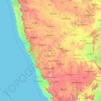
Name: Karnataka topographic map, elevation, terrain.
Location: Karnataka, India (11.59456 74.05439 18.47665 78.58808)
Average elevation: 386 m
Minimum elevation: -1 m
Maximum elevation: 1,771 m
The bulk of the state is in the Bayaluseeme region, the northern part of which is the second-largest arid region in India. The highest point in Karnataka is the Mullayanagiri hills in Chikmagalur district which has an altitude of 1,925 metres (6,316 ft). The two main river systems of the state are the Krishna and its tributaries, the Bhima, Ghataprabha, Vedavathi, Malaprabha and Tungabhadra in North Karnataka, and the Kaveri and its tributaries, the Hemavati, Shimsha, Arkavati, Lakshmana Thirtha and Kabini, in South Karnataka. Most of these rivers flow out of Karnataka eastward, reaching the sea at the Bay of Bengal. Other prominent rivers such as the Sharavati in Shimoga and Netravati in Dakshina Kannada flow westward, reaching the sea at the Arabian Sea. A large number of dams and reservoirs are constructed across these rivers which richly add to the irrigation and hydroelectricity power generation capacities of the state.
Other topographic maps
Click on a map to view its topography, its elevation and its terrain.
Hyderabad
India > Telangana > Bahadurpura mandal
Hyderabad, Bahadurpura mandal, Hyderabad District, Telangana, India
Average elevation: 549 m
Dehradun
India > Uttarakhand > Dehradun
Dehradun, Dehradun District, Uttarakhand, 248001, India
Average elevation: 904 m
Chennai
India > Tamil Nadu > Chennai
Chennai, Chennai District, Tamil Nadu, India
Average elevation: 8 m
Siliguri
India > West Bengal > Siliguri Subdivsion
Siliguri, Siliguri Subdivsion, Darjeeling District, West Bengal, India
Average elevation: 121 m
Chandwad
India > Maharashtra > Washi
Chandwad, Washi, Dharashiv District, Maharashtra, 413534, India
Average elevation: 722 m
Bhopal
India > Madhya Pradesh > Huzur Tahsil
Bhopal, Huzur Tahsil, Bhopal District, Madhya Pradesh, 462001, India
Average elevation: 498 m
Thiruvananthapuram
India > Kerala > Thiruvananthapuram
Thiruvananthapuram, Thiruvananthapuram District, Kerala, 695001, India
Average elevation: 33 m
Bengaluru
India > Karnataka > Bangalore North
Bengaluru, Bangalore North, Bengaluru Urban District, Karnataka, India
Average elevation: 881 m
Shitlakhet
India > Uttarakhand > Almora
Shitlakhet, Almora, Almora District, Uttarakhand, 263678, India
Average elevation: 1,723 m
Jaiti
India > Uttarakhand > Ranikhet
Jaiti, Ranikhet, Almora District, Uttarakhand, 263645, India
Average elevation: 1,504 m
Kaigaon
India > Maharashtra > Sillod
Kaigaon, Sillod, Chhatrapati Sambhajinagar District, Maharashtra, India
Average elevation: 610 m
Dahej
India > Gujarat > Vagra Taluka
Dahej, Vagra Taluka, Bharuch District, Gujarat, 393125, India
Average elevation: 6 m
Ghuttu
India > Uttarakhand > Ghansali
Ghuttu, Ghansali, Tehri Garhwal District, Uttarakhand, India
Average elevation: 1,856 m
Gotegaon
India > Madhya Pradesh > Gotegaon Tahsil
Gotegaon, Gotegaon Tahsil, Narsinghpur District, Madhya Pradesh, India
Average elevation: 421 m
Musi River
Musi River, Hyderabad, Uppal mandal, Medchal–Malkajgiri, Telangana, 5000036, India
Average elevation: 490 m
Krishnagiri District
Krishnagiri District, Tamil Nadu, India
Average elevation: 653 m
Delhi
India > Delhi > Kotwali Tehsil
Delhi, Kotwali Tehsil, Central Delhi, Delhi, 110006, India
Average elevation: 216 m
Dhanaura
Dhanaura, Amroha District, Uttar Pradesh, India
Average elevation: 213 m
Desuri Tehsil
Desuri Tehsil, Pali District, Rajasthan, India
Average elevation: 428 m
Gudisa
India > Andhra Pradesh > Maredumilli
Gudisa, Maredumilli, Alluri Sitharama Raju, Andhra Pradesh, India
Average elevation: 974 m
Darjeeling district
Darjeeling district, West Bengal, India
Average elevation: 728 m
Anaikatti
India > Tamil Nadu > Coimbatore North
Anaikatti, Coimbatore North, Coimbatore District, Tamil Nadu, 678741, India
Average elevation: 623 m
Uley
India > Ladakh > Khalsi tehsil
Uley, Khalsi tehsil, Leh District, Ladakh, India
Average elevation: 4,249 m
Madurai
India > Tamil Nadu > Madurai
Madurai, Madurai South, Madurai district, Tamil Nadu, India
Average elevation: 138 m