
Iași topographic map
Interactive map
Click on the map to display elevation.
About this map
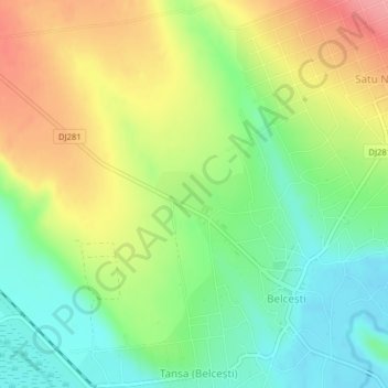
Name: Iași topographic map, elevation, terrain.
Location: Tansa (Belcești), Iași, Romania (47.31186 27.07194 47.31571 27.07881)
Average elevation: 121 m
Minimum elevation: 79 m
Maximum elevation: 175 m
Other topographic maps
Click on a map to view its topography, its elevation and its terrain.
Bejan-Târnăvița
Romania > Hunedoara > Căinelu de Jos
Bejan-Târnăvița, Căinelu de Jos, Șoimuș, Hunedoara, 337453, Romania
Average elevation: 277 m