
Thank you for supporting this site ❤️
Make a donation
Make a donation
Baru topographic map
Click on the map to display elevation.
Thank you for supporting this site ❤️
Make a donation
Make a donation
About this map
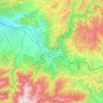
Name: Baru topographic map, elevation, terrain.
Location: Baru, Hunedoara, Romania (45.38504 23.09587 45.56850 23.36259)
Average elevation: 866 m
Minimum elevation: 355 m
Maximum elevation: 1,788 m
Thank you for supporting this site ❤️
Make a donation
Make a donation
Other topographic maps
Click on a map to view its topography, its elevation and its terrain.