
Thank you for supporting this site ❤️
Make a donation
Make a donation
Bran topographic map
Click on the map to display elevation.
Thank you for supporting this site ❤️
Make a donation
Make a donation
About this map
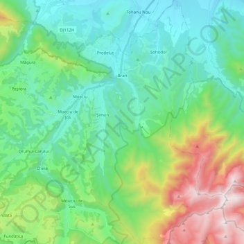
Name: Bran topographic map, elevation, terrain.
Location: Bran, Brașov, Romania (45.42016 25.33314 45.55922 25.45612)
Average elevation: 1,140 m
Minimum elevation: 666 m
Maximum elevation: 2,499 m
Thank you for supporting this site ❤️
Make a donation
Make a donation
Other topographic maps
Click on a map to view its topography, its elevation and its terrain.