
Thank you for supporting this site ❤️
Make a donation
Make a donation
Iablanița topographic map
Click on the map to display elevation.
Thank you for supporting this site ❤️
Make a donation
Make a donation
About this map
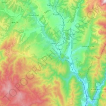
Name: Iablanița topographic map, elevation, terrain.
Location: Iablanița, Caraș-Severin, Romania (44.85271 22.21012 45.01837 22.34785)
Average elevation: 542 m
Minimum elevation: 118 m
Maximum elevation: 1,265 m
Thank you for supporting this site ❤️
Make a donation
Make a donation
Other topographic maps
Click on a map to view its topography, its elevation and its terrain.