
Make a donation
North America topographic map
Click on the map to display elevation.
Make a donation
North America
North America's topography is characterized by its diverse and dramatic landscapes, stretching from the towering Rocky Mountains in the west to the expansive Great Plains in the central region, and the rugged Appalachian Mountains in the east. The Rocky Mountains, which include peaks exceeding 20,000 feet (6,096 meters), create a formidable spine that bisects the continent and contributes to significant climatic variations across the region. East of the Rockies, the Great Plains—often referred to as the "Breadbasket of North America"—are marked by vast, flat expanses of fertile soil that are ideal for agriculture, ranging from rich grasslands to rolling hills. This area is dotted with numerous rivers, including the Mississippi, which is one of the longest river systems in the world, playing a crucial role in the continent’s drainage and ecosystem. In the northeastern part of North America, the Appalachian Mountains are notable for their ancient, eroded peaks and deep valleys, while the Atlantic Coastal Plain features low-lying wetlands and sandy beaches that support diverse ecosystems. Further north, the Canadian Shield presents a rugged, rocky terrain interspersed with countless lakes formed by glacial activity, illustrating the continent's geological history.
Make a donation
About this map
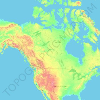
Name: North America topographic map, elevation, terrain.
Location: North America (26.00000 -134.00000 76.00000 -84.00000)
Average elevation: 294 m
Minimum elevation: -2 m
Maximum elevation: 5,837 m
Make a donation
Other topographic maps
Click on a map to view its topography, its elevation and its terrain.
India
India's topography is a tapestry of diverse terrains, each contributing to the country's unique geographical identity. In the north, the majestic Himalayas form a formidable barrier, with towering peaks like Kangchenjunga reaching elevations of 8,586 meters (28,169 feet), making it the highest point in India.…
Average elevation: 1,017 m
Sri Lanka
Sri Lanka's topography is characterized by a diverse landscape that includes the Central Highlands, plains, and coastal regions. The Central Highlands, located in the south-central part of the island, form its rugged heartland, with the highest peak, Pidurutalagala, reaching 2,524 meters (8,281 feet). This…
Average elevation: 50 m
Mumbai
India > Maharashtra > Mumbai
Mumbai is on a narrow peninsula on the southwest of Salsette Island, which lies between the Arabian Sea to the west, Thane Creek to the east and Vasai Creek to the north. Mumbai's suburban district occupies most of the island. Navi Mumbai is east of Thane Creek and Thane is north of Vasai Creek. Mumbai…
Average elevation: 18 m
Chennai
Chennai is located on the southeastern coast of India in the northeastern part of Tamil Nadu on a flat coastal plain known as the Eastern Coastal Plains with an average elevation of 6.7 m (22 ft) and highest point at 60 m (200 ft). Chennai's soil is mostly clay, shale and sandstone. Clay underlies most of the…
Average elevation: 8 m
Make a donation
Maharashtra
Maharashtra with a total area of 307,713 km2 (118,809 sq mi), is the third-largest state by area in terms of land area and constitutes 9.36 per cent of India's total geographical area. The State lies between 15°35' N to 22°02' N latitude and 72°36' E to 80°54' E longitude. It occupies the western and…
Average elevation: 346 m
Toronto
Despite its deep ravines, Toronto is not remarkably hilly, but its elevation does increase steadily away from the lake. Elevation differences range from 76.5 metres (251 ft) above sea level at the Lake Ontario shore to 209 m (686 ft) above sea level near the York University grounds in the city's north end at…
Average elevation: 139 m
Delhi
The topography of the medieval fort Purana Qila on the banks of the river Yamuna matches the literary description of the citadel Indraprastha in the Sanskrit epic Mahabharata; however, excavations in the area have revealed no signs of an ancient built environment. From the early 13th century until the mid-19th…
Average elevation: 218 m
Snohomish County
The lowland areas of western Snohomish County generally has a temperate Mediterranean climate similar to the rest of the central Puget Sound region with dry summers and wet winters. The county's weather is heavily influenced by maritime systems, pushed by prevailing westerly winds but dampened by the Olympic…
Average elevation: 649 m
Make a donation
Reno
United States > Nevada > Washoe County
Reno is just east of the Sierra Nevada on the western edge of the Great Basin at an elevation of about 4,400 feet (1,300 m) above sea level. Numerous faults exist throughout the region. Most of these are normal (vertical motion) faults associated with the uplift of the various mountain ranges, including the…
Average elevation: 1,650 m
Kerala
Kerala was alternatively called Malabar in the foreign trade circles. Earlier, the term Malabar had also been used to denote Tulu Nadu and Kanyakumari which lie contiguous to Kerala on the southwestern coast of India, in addition to the modern state of Kerala. The people of Malabar were known as Malabars.…
Average elevation: 251 m
Make a donation
Jammu and Kashmir
Jammu and Kashmir is home to several valleys such as the Kashmir Valley, Tawi Valley, Chenab Valley, Poonch Valley, Sind Valley, and Lidder Valley. The Kashmir valley is 100 km (62 mi) wide and 15,520.3 km2 (5,992.4 sq mi) in area. The Himalayas divide the Kashmir valley from the Tibetan plateau while the Pir…
Average elevation: 2,430 m
Uttar Pradesh
Uttar Pradesh, with a total area of 243,290 square kilometres (93,935 sq mi), is India's fourth-largest state in terms of land area and is roughly of same size as United Kingdom. It is situated on the northern spout of India and shares an international boundary with Nepal. The Himalayas border the state on the…
Average elevation: 954 m
Hyderabad
India > Telangana > Bahadurpura mandal
Hyderabad (/ˈhaɪdərəbæd/ HY-dər-ə-bad; Telugu: [ˈɦaɪ̯daraːbaːd], Urdu: [ˈɦɛːdəɾaːbaːd]) is the capital and largest city of the Indian state of Telangana. It occupies 650 km2 (250 sq mi) on the Deccan Plateau along the banks of the Musi River, in the northern part of Southern India. With an…
Average elevation: 549 m
Make a donation
Bengaluru
India > Karnataka > Bangalore North
Bengaluru (formerly Bangalore) is situated in the southeastern part of Karnataka, India, within the Bengaluru Urban district. It lies at an elevation of approximately 900 meters (3,000 feet) above sea level, on the Deccan Plateau. This elevated position gives the city a moderate climate, with temperatures…
Average elevation: 881 m
Newport Beach
United States > California > Orange County
Newport Beach extends in elevation from sea level to the 1,161 ft (354 m) summit of Signal Peak in the San Joaquin Hills, but the official elevation is 25 ft (7.6 m) above sea level at a location of 33°37′0″N 117°53′51″W / 33.61667°N 117.89750°W / 33.61667; -117.89750 (33.616671, −117.897604).
Average elevation: 14 m
Aktobe
Kazakhstan > Aqtöbe region > Astana District
After the territories of modern Kazakhstan were annexed to the Russian Empire, due to the need for strong points and retail outlets, many cities appeared, one of which was Aktobe. In the architecture of the cities of Southern Kazakhstan, the influence of the Central Asian khanates is traced, and the…
Average elevation: 276 m
Pecatu
Pecatu is located in South Kuta District of Badung Regency. It is at the western end of the Bukit Peninsula in south Bali, and has a hilly topography with limestone cliffs isolating small, short beaches that have been privately developed. Nusa Dua, on the opposite side of the peninsula, is flat and is a…
Average elevation: 78 m
Make a donation
Atlanta
United States > Georgia > Fulton County
Atlanta (/ætˈlæn(t)ə/ at-LAN-(t)ə) is the capital and most populous city in the U.S. state of Georgia. It is the seat of Fulton County, and a portion of the city extends into neighboring DeKalb County. While not included in city limits, unincorporated areas that carry an Atlanta address spill into…
Average elevation: 284 m
Make a donation
Odisha
Three-quarters of the state is covered in mountain ranges. Deep and broad valleys have been made in them by rivers. These valleys have fertile soil and are densely populated. Odisha also has plateaus and rolling uplands, which have lower elevation than the plateaus. The highest point in the state is Deomali at…
Average elevation: 228 m
Make a donation
Mariana Trench National Wildlife Refuge
Average elevation: 0 m
Washington
Washington is the 18th largest state, with an area of 71,362 square miles (184,827 km2), and the 13th most populous state, with more than 7.4 million people. Approximately 60 percent of Washington's residents live in the Seattle metropolitan area, the center of transportation, business, and industry along…
Average elevation: 796 m
Make a donation
Uttarakhand
Uttarakhand lies on the southern slope of the Himalaya range, and the climate and vegetation vary greatly with elevation, from glaciers at the highest elevations to subtropical forests at the lower elevations. The highest elevations are covered by ice and bare rock. Below them, between 3,000 and 5,000 metres…
Average elevation: 2,102 m
Make a donation
Ordu
Ordu is a strip of Black Sea coast and the hills behind, historically an agricultural and fishing area and in recent years, tourism has seen an increase, mainly visitors from Russia and Georgia, as Ordu boasts some of the best beaches, rivers, and lush, green mountains on the Black Sea coast. Walking in the…
Average elevation: 705 m
Madurai
India > Tamil Nadu > Madurai
Madurai is located at 9°56′N 78°07′E / 9.93°N 78.12°E / 9.93; 78.12. It has an average elevation of 101 metres. The city of Madurai lies on the flat and fertile plain of the river Vaigai, which runs in the northwest-southeast direction through the city, dividing it into two almost equal…
Average elevation: 138 m
Tamil Nadu
The annual rainfall of the state is about 945 mm (37.2 in) of which 48 per cent is through the northeast monsoon, and 32 per cent through the southwest monsoon. Since the state is entirely dependent on rains for recharging its water resources, monsoon failures lead to acute water scarcity and severe drought.…
Average elevation: 253 m
Make a donation
Kanniyakumari
Kanyakumari district has a varied topography with sea on three sides and the mountains of the Western Ghats bordering the northern side. Except for a small stretch of land to the west of Kanyakumari town, almost the entire district is sandwiched between the Western Ghats and the Arabian Sea - the only district…
Average elevation: 226 m
Asheville
United States > North Carolina > Buncombe County
Asheville has a humid subtropical climate (Köppen Cfa), resembling the rest of the Piedmont region of the southeastern U.S., but with noticeably cooler temperatures due to the higher elevation; it is part of USDA Hardiness zone 7a. The area's summers in particular, though warm, are not as hot as summers in…
Average elevation: 727 m
Siliguri
India > West Bengal > Matigara block
Siliguri located at the foothills of the eastern Himalayas at a location of 26°43′N 88°26′E / 26.71°N 88.43°E / 26.71; 88.43. This city is spread over an area of 260 km2 within the Siliguri Corridor, also known as the Chicken's neck. The city is surrounded by dense forests towards north and…
Average elevation: 121 m
Make a donation
Bihar
Bihar covers a total area of 94,163 km2 (36,357 sq mi), with an average elevation above sea level of 173 feet (53 m). It is land locked by Nepal in the north, Jharkhand in the south West Bengal in the east and Uttar Pradesh to the west. It has three parts on the basis of physical and structural conditions: the…
Average elevation: 605 m
Make a donation
Basanti
Basanti CD block is located at 22°11′54″N 88°42′50″E / 22.1983°N 88.7139°E / 22.1983; 88.7139. It has an average elevation of 6 metres (20 ft).
Average elevation: 3 m
Make a donation
Kapuas River
The river is 1,143 km (710 mi) long and 99,000 km2 (38,000 mi2) the river basin covers more than 67% of West Kalimantan. The river originates near the center of Borneo, south of the Indonesian-Malaysian border, in the joint between the western slope of the Müller Mountain Range, which runs through the island…
Average elevation: 141 m
Make a donation
Make a donation
Dubai Emirate
Dubai lies directly in the Arabian Desert. Still, its topography is significantly different from that of the southern portion of the UAE, with much of Dubai's landscape highlighted by sandy desert patterns. In contrast, gravel deserts dominate much of the country's south. The sand consists mostly of crushed…
Average elevation: 64 m
Goa
Goa is a part of the coastal country known as the Konkan, which is an escarpment rising up to the Western Ghats range of mountains, which separate it from the Deccan Plateau. The highest point is the Sonsogor Peak, with an altitude of 1,026 m (3,366 ft). Goa has a coastline of 160 km (99 mi).
Average elevation: 228 m
Make a donation
Himachal Pradesh
Due to extreme variation in elevation, great variation occurs in the climatic conditions of Himachal Pradesh. The climate varies from hot and humid subtropical in the southern tracts to, with more elevation, cold, alpine, and glacial in the northern and eastern mountain ranges. The state's winter capital,…
Average elevation: 2,869 m
Sikkim
Situated in the Himalayan mountains, the state of Sikkim is characterised by mountainous terrain. Almost the entire state is hilly, with an elevation ranging from 280 metres (920 ft) in the south at the border with West Bengal to 8,586 metres (28,169 ft) in northern peaks near Nepal and Tibet. The summit of…
Average elevation: 3,784 m
Rajasthan
The Aravalli Range runs across the state from the southwest peak Guru Shikhar (Mount Abu), which is 1,722 metres (5,650 ft) in height, to Khetri in the northeast. This range divides the state into 60% in the northwest of the range and 40% in the southeast. The northwest tract is sandy and unproductive with…
Average elevation: 254 m
Make a donation
Make a donation
Hainan
Even when Hainan Island was a part of Guangdong, it had a considerable amount of local autonomy; the southern half of the island was an autonomous prefecture. Hainan's elevation to provincial level in 1988 increased its accountability to the Central People's Government, but by designating the new province a…
Average elevation: 95 m
Make a donation
Tacoma
United States > Washington > Pierce County
Tacoma is at 47°14′29″N 122°27′34″W / 47.24139°N 122.45944°W / 47.24139; -122.45944 (47.241371, −122.459389). Its official elevation is 381 feet (116 m), varying between sea level and about 500 feet (150 m).
Average elevation: 67 m
Make a donation
Haywood County
United States > North Carolina
Haywood County is situated amidst the Blue Ridge Mountains and contains parts of several major subranges of the Blue Ridge, namely the Great Smoky Mountains in the west and the Plott Balsams and Great Balsam Mountains in the south. Notable peaks in the county include Cold Mountain, at 6,030 feet (1,840 m),…
Average elevation: 1,044 m
Pune City
Pune lies on the western margin of the Deccan plateau, at an altitude of 560 m (1,840 ft) above sea level. It is on the leeward side of the Sahyadri mountain range, which forms a barrier from the Arabian Sea. It is a hilly city, with Vetal Hill rising to 800 m (2,600 ft) above sea level. The Sinhagad fort is…
Average elevation: 616 m
Make a donation
Coimbatore
Apart from the species common to the plains, wild elephants, wild boars leopards, tigers, bison, species of deer, Nilgiri tahr, sloth bear and black-headed oriole can be found. The Anamalai Wildlife Sanctuary 88 km (55 mi) in the Western Ghats at an altitude of 1,400 meters covers an area of 958 km2. More than…
Average elevation: 551 m
Make a donation
Karnataka
The bulk of the state is in the Bayaluseeme region, the northern part of which is the second-largest arid region in India. The highest point in Karnataka is the Mullayanagiri hills in Chikmagalur district which has an altitude of 1,925 metres (6,316 ft). The two main river systems of the state are the Krishna…
Average elevation: 386 m
Make a donation
Make a donation
Serbia
Ancient mountains in the southeast corner of the country belong to the Rilo-Rhodope Mountain system. Elevation ranges from the Midžor peak of the Balkan Mountains at 2,169 metres (7,116 feet) (the highest peak in Serbia, excluding Kosovo) to the lowest point of just 17 metres (56 feet) near the Danube river…
Average elevation: 518 m
Make a donation