
Make a donation
Kapuas River topographic map
Click on the map to display elevation.
Make a donation
Kapuas River
The river is 1,143 km (710 mi) long and 99,000 km2 (38,000 mi2) the river basin covers more than 67% of West Kalimantan. The river originates near the center of Borneo, south of the Indonesian-Malaysian border, in the joint between the western slope of the Müller Mountain Range, which runs through the island center, and the southern slope of the Upper Kapuas Range (Indonesian: Kapuas Hulu), which is located more to the west. For about 165 km (103 mi) it flows through a mountainous terrain and then descends to a marshy plain. There, the elevation decreases by only 50 m (0.031 mi) over 902 km (560 mi) from Putussibau to the river delta.
Make a donation
About this map
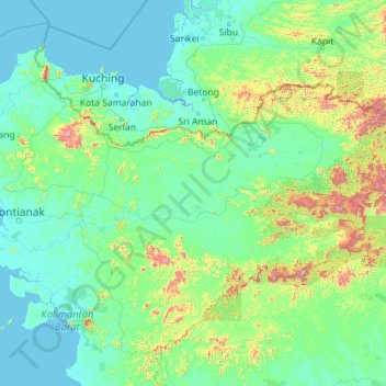
Name: Kapuas River topographic map, elevation, terrain.
Location: Kapuas River, Kalimantan, Indonesia (-0.39902 109.08428 1.00356 113.63732)
Average elevation: 141 m
Minimum elevation: -4 m
Maximum elevation: 1,992 m
Make a donation
Other topographic maps
Click on a map to view its topography, its elevation and its terrain.
Make a donation
Make a donation
Make a donation
Tambora
Indonesia > West Nusa Tenggara
Mount Tambora, or Tomboro, is an active stratovolcano in West Nusa Tenggara, Indonesia. Located on Sumbawa in the Lesser Sunda Islands, it was formed by the active subduction zones beneath it. Before the 1815 eruption, its elevation reached more than 4,300 metres (14,100 feet) high, making it one of the…
Average elevation: 1,393 m
Make a donation
Bekasi
The City of Bekasi is a part of the Bekasi river basin, located in the downstream area of the basin with slopes ranging from 0 to 2% and elevations between 11 meters to 81 meters above sea level. The city of Bekasi is part of the Bekasi river basin and is located in the downstream area of the basin, with a…
Average elevation: 23 m
Make a donation
Bandung
Bandung (Sundanese: ᮘᮔ᮪ᮓᮥᮀ, romanized: Bandung, Sundanese pronunciation: [ˈbandʊŋ]; /ˈbɑːndʊŋ/) is the capital city of the Indonesian province of West Java. It has a population of 2,452,943 within its city limits according to the official estimates as at mid 2021, making it the fourth most…
Average elevation: 893 m
Wakatobi National Park
Indonesia > Southeast Sulawesi
It consists of four larger islands: Wangi-Wangi, Kaledupa, Tomia and Binongko, as well as many small islands such as Tokobao, North Lintea, South Lintea, Kampenaune, Hoga and Tolandono. The highest elevation is 274 metres (899 ft) on Wangi-Wangi, followed by Lagole Hill (271m) on Tomia, Terpadu Hill (222 m) on…
Average elevation: 1 m
Make a donation
Make a donation
Make a donation
Make a donation
Make a donation
Make a donation
Make a donation
Make a donation
Make a donation
Make a donation
Tembagapura
Indonesia > Central Papua > Mimika
Tembagapura is situated on a rocky plain at an altitude of 1,930 metres (6,330 ft) at the base of Mount Zaagkam, which lies 16 kilometres (9.9 mi) southeast of the mine. The town is in the Sudirman Range, not far from Puncak Jaya (Mount Carstens), the highest peak in Oceania. The area gets about 3,220…
Average elevation: 2,488 m
Make a donation
Make a donation
Make a donation
Make a donation
Make a donation
Rinjani
Indonesia > West Nusa Tenggara
In September 1995 an aviation report was issued concerning an unconfirmed ash cloud from Rinjani. A NOTAM about volcanic activity from Rinjani was issued by the Bali Flight Information Region on the morning of 12 September. An ash cloud was reportedly drifting to the south west with the cloud top around 4 km…
Average elevation: 3,071 m
Make a donation
Make a donation
Make a donation
Make a donation
Make a donation