
Make a donation
Hainan topographic map
Click on the map to display elevation.
Make a donation
Hainan
Even when Hainan Island was a part of Guangdong, it had a considerable amount of local autonomy; the southern half of the island was an autonomous prefecture. Hainan's elevation to provincial level in 1988 increased its accountability to the Central People's Government, but by designating the new province a special economic zone the central government expressed its intent to allow Hainan maximum flexibility in devising programs to facilitate foreign investment and economic growth. Administratively, the province has been divided into five economic major districts.
Make a donation
About this map
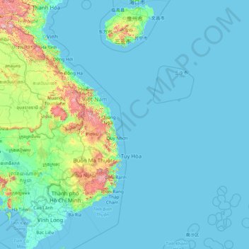
Name: Hainan topographic map, elevation, terrain.
Location: Hainan, China (8.66504 108.38823 20.28796 118.05515)
Average elevation: 95 m
Minimum elevation: -3 m
Maximum elevation: 2,370 m
Make a donation
Other topographic maps
Click on a map to view its topography, its elevation and its terrain.
Chongqing
The central urban area of Chongqing, or Chongqing proper, is a city of unique features. Built on mountains and partially surrounded by the Yangtze and Jialing rivers, it is known as a "mountain city" and a "city on rivers". The night scene of the city is very illuminated, with millions of lights and their…
Average elevation: 318 m
Tai Mo Shan
Tai Mo Shan is the highest peak in Hong Kong, with an elevation of 957 metres (3,140 ft) above the Hong Kong Principal Datum [zh], or around 956 metres (3,136 ft) above mean sea level. It is located at approximately the geographical centre of the New Territories.
Average elevation: 600 m
K2
China > Xinjiang > Cenling County
K2 is nicknamed "The King of Mountains" and "The Mountaineers' Mountain", as well as "The Mountain of Mountains", a phrase popularized by Italian climber Reinhold Messner in his book on K2. Although the summit of Everest is at a higher altitude, K2 is a more difficult and dangerous climb. This is in part due…
Average elevation: 7,482 m
Make a donation
Xi'an
China > Shaanxi > Weiyang District > Xi'an
Xi'an lies on the Guanzhong Plain in the south-central part of Shaanxi province, on a flood plain created by the eight surrounding rivers and streams. The city has an average elevation of 400 metres (1,312 ft) above sea level and an annual precipitation of 553 mm (21.8 in). The urban area of Xi'an is located…
Average elevation: 412 m
Make a donation
Make a donation
Himalayas
The Himalayas, or Himalaya, is a mountain range in Asia separating the plains of the Indian subcontinent from the Tibetan Plateau. The range has some of the Earth's highest peaks, including the highest, Mount Everest. More than 100 peaks exceeding elevations of 7,200 m (23,600 ft) above sea level lie in the…
Average elevation: 2,385 m
Make a donation
Alar National Wetland Park
China > Xinjiang > Taxkorgan Tajik Autonomous County > Tashkorgan Town > 瓦尔希迭村 ۋەرشىدې
Average elevation: 3,074 m
Make a donation
Make a donation
Tagong
A gompa is where the Tagong Monastery is located. The gompa is one of the most important in the in Tibetan Pel Lhagong. The Tagong Monastery was established with reference to a nearby sacred mountain, Mt. Yala or Zhara Lhaste, which is 5,820 metres (19,090 ft) in elevation.
Average elevation: 3,874 m
Make a donation
Make a donation
Make a donation
Make a donation
Make a donation
Make a donation
Make a donation
Make a donation
Make a donation
Make a donation
Make a donation
Make a donation
Make a donation
Mount Kailash
China > Tibet > Purang County > Darchen
Mount Kailash (also Kailasa, Gang Tise and Gang Rinpoche or Kangrinboqê) is a mountain in Ngari Prefecture, Tibet Autonomous Region of China. It lies in the Gangdise Shan mountain range of the Transhimalaya, in the western part of the Tibetan Plateau. The peak of Mount Kailash is located at an elevation of…
Average elevation: 5,756 m
Make a donation
Make a donation
Make a donation
Make a donation
Make a donation
Make a donation